Editorial: Lessons from Isaias must be learned fast
Published in Op Eds
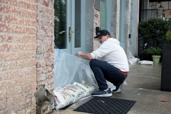
The fact that Hurricane Isaias didn’t ruin more lives or property is not because Florida got smarter about predicting windstorms. It’s because Florida got lucky.
Isaias is the latest example of rapid intensification. It was a tropical storm Wednesday morning, a hurricane by midnight and 24 hours later, a Category 3 packing 120 mph winds. It made landfall as a weakened Cat-2. Other coastal regions haven’t been as lucky. In 2024, Milton grew by 90 mph in just 17 hours before landfall near Sarasota. In the Pacific, this year’s Polo exploded from a tropical storm to Category 5 monster overnight.
This is a terrifying pattern for Floridians near coastlines or in evacuation zones. People hunkering down for a Cat-1 could quickly face a much worse storm than the one they expected.
Rapid intensification is not a new threat, but it’s becoming more frequent. Hot oceans accelerate wind speed. Hotter air holds more moisture. More moisture dumps more rain, which means more severe flooding.
Ideally, elected officials facing this threat would launch a multi-pronged attack, starting with solid research on how and why it happens. But in the wrong hands, even windstorms are political tools. Isaias is no exception.
U.S. Rep. Jimmy Patronis represents much of the Panhandle. As Isaias took aim at his people, he was calling out the World Meteorological Organization for not using “American names people can pronounce.” Such a cheap bid for culture-war clicks would quickly be forgotten if it were the only hurricane politicking.
Federal help is clearly tied to whether state officials stay in President Donald Trump’s good graces. FEMA quickly pledged post-Isaias relief to red Florida. But in blue-state Illinois, FEMA is refusing aid after tornadoes, flooding and hurricane-strength wind gusts tore through eight counties in August. Days after Colorado’s governor refused to release convicted felon and election conspirator Tina Peters as Trump demanded, the administration tried to shut down the National Center for Atmospheric Research’s supercomputer in Colorado.
Pure retribution, and it gets worse. The Trump administration is relentlessly pushing to strip away crucial windstorm information. There are fewer government weather balloons tracking barometric pressure, humidity, wind speed and direction.
Plans for next-generation weather satellites to replace aging technology are back-burnered. And for a second year, the administration has repeatedly sought to cripple the Office of Oceanic and Atmospheric Research, a key to accurate storm warnings.
In 2024, Gov. Ron DeSantis proudly signed a law ripping the words climate change from state laws. The Florida Department of Education last month released revised K-12 science education standards that, if adopted, will kneecap weather science studies in Florida. This in a state where weather is everything. It underpins the economic drivers of tourism and agriculture. Windstorm insurance premiums can undermine home ownership.
Weather science is not the enemy. The earth is warming, whether politicians believe it or not. The ocean is absorbing most of that heat, and the heat fuels windstorms.
It’s not clear whether rapid intensification of hurricanes is solely caused by a heating planet. But finding out the cause and making sure people are warned and prepared means trusting science.
Next year, the unprecedented El Niño weather pattern currently supercharging hurricanes in the Pacific and suppressing hurricanes in the Atlantic will begin to subside. There’s also speculation that its counterpart, La Niña, will return in mid-2027, and with it, a greater risk of Atlantic storms. Florida and Washington need to support and enhance weather science — soon. No state with 1,350 miles of ocean coastline stays lucky forever.
_____
©2026 South Florida Sun Sentinel. Visit at sun-sentinel.com. Distributed by Tribune Content Agency, LLC.















































Comments