Colorado wildfires: More Aspen Acres evacuations lifted, Steamboat fires snowmaking guns as precaution against Fishhook fire
Published in News & Features
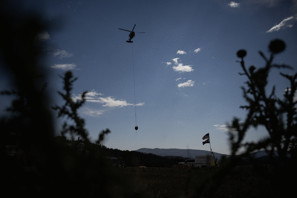
DENVER — More evacuations were lifted for the Aspen Acres fire burning in southern Colorado on Tuesday, allowing residents to return home after weeks of uncertainty.
The Aspen Acres fire is one of six active wildfires burning across Colorado that have together consumed nearly 208,000 acres, or 325 square miles, according to fire officials. That’s more than one-third the size of Douglas County.
Aspen Acres fire in Custer and Pueblo counties
More evacuations were lifted Tuesday for Pueblo County residents north and east of the Aspen Acres fire, the growth of which has slowed in recent days, according to the sheriff’s office.
As of Tuesday morning, the Aspen Acres fire burning in southern Colorado had consumed 99,077 acres, or 155 square miles, and was 36% contained, fire officials said.
The wildfire is Colorado’s largest active wildfire and the seventh-largest in the state’s recorded history, behind the 2018 Spring Creek fire that consumed 108,045 acres.
The Aspen Acres fire has destroyed at least 851 structures. It’s unclear how many of those are homes, but law enforcement in Pueblo and Custer counties previously announced that at least 337 homes and four businesses had been destroyed.
Large swaths of evacuated residents have been able to return home this week as mandatory evacuation orders were downgraded to pre-evacuation status on the fire’s east side. Evacuations remain in place on the fire’s west side, and part of Fremont County also remains on pre-evacuation status.
Updated evacuation maps for Pueblo and Custer counties and for Fremont County can be found online.
The following roads remained closed for the fire as of Monday morning, according to the Colorado Department of Transportation:
•Colorado 96 in both directions between Silver Cliff and Siloam Road west of Pueblo
•Colorado 165 in both directions between McKenzie Junction and Interstate 25
•Colorado 78 in both directions between Colorado 165 and Rock Creek Road west of Pueblo
The exact origin of the fire remains under investigation, but officials believe it was human-caused.
Green Ridge and Fishhook fires
Two wildfires sparked south of Steamboat Springs in northern Colorado on Sunday, according to Routt County officials.
As of Monday evening, the Fishhook fire had scorched an estimated 200 acres with no containment in Routt National Forest, near Rabbit Ears Pass, according to the U.S. Forest Service.
The fire is less than a mile away from U.S. 40, but the highway remained open, fire officials said in an 8 p.m. Monday update. If the fire continues to grow south toward the highway, U.S. 40 may close.
“The fire became active this afternoon, spotting ahead of itself and growing primarily south,” fire officials wrote in the update.
Steamboat Ski Resort, roughly three miles from the fire, fired up 41 of the resort’s snowmaking guns in the Tomahawk and Spike areas and around the Rendezvous Lodge on Monday to saturate the ground in case the flames advanced.
“While it is not currently an immediate threat, we recognize that wildfires can be unpredictable, and we are taking proactive precautions,” resort officials said on Facebook.
Mandatory evacuations remained in place on Tuesday for the Green Ridge fire burning near the Stagecoach Reservoir, which was last estimated at 44 acres with 27% containment, according to Routt County officials. The fire had threatened 480 structures when Gov. Jared Polis issued an emergency declaration on Sunday, but as of Monday afternoon, none had been damaged or destroyed.
The mandatory evacuation zone is bordered to the west by Routt County Road 212, to the south by Green Ridge, to the east by Wood Chuck Hill and to the north by Stage Coach Reservoir, according to the Routt County evacuation map.
Pre-evacuations were also in place at that time east and north of the mandatory evacuation zone. That area was bordered to the north by Stagecoach State Park and Blacktail Mountain, to the west by Routt County Road 16, to the east by Service Creek and Bushy Creek and to the south by Colt Trail.
An evacuation center is available at Soroco High School, 305 Grant Ave. in Oak Creek, according to Routt County officials.
The cause of the fires remains under investigation.
Gold Mountain fire near Ouray
A pilot fighting a wildfire north of Ouray died Sunday evening when his helicopter crashed into the Silver Jack Reservoir in southwestern Gunnison County, according to the sheriff’s office.
Nicholas Dale, a 56-year-old federally contracted fire aviation pilot from Sooke, British Columbia, died in the crash, according to the Gunnison County Sheriff’s Office.
The Gold Mountain fire saw minimal growth Monday, consuming a total of 36,965 acres with 12% containment, fire officials said in a Tuesday morning update. That's roughly 58 square miles.
More than 980 personnel remained on scene to fight the wildfire, according to Rocky Mountain Complex Incident Management Team 2, which took control of the fire response on Tuesday.
Mandatory evacuations remained in place on Tuesday for residents of Ouray and Gunnison counties north of the fire, according to the evacuation map.
The Ouray County evacuation zone was bordered to the west by County Road 8 and County Road 10, to the south by Baldy Peak, to the east by Green Mountain and the Cimarron Ridge and to the north by Tommy Creek and Deer Creek.
Evacuations were also in effect northeast of the Cimarron Ridge, along the border of Gunnison and Montrose counties, according to the map. That area is bordered to the north by Washboard Rock, to the east by Gunnison County Road 864A, to the south by Hampden Lake and to the west by Cimarron Ridge.
Montrose County residents north of the mandatory evacuation zone and Gunnison County residents to the east of the zone were on pre-evacuation status at that time.
Pre-evacuation orders remained in effect for the previously evacuated area west of the wildfire's southern burn area, including Lake Lenore and bordered to the west by U.S. 550, to the north by Cutler Creek, to the east by the wildfire burn area and to the south by Bridalveil Creek.
Evacuated residents can seek shelter at the Ridgway Secondary School, 1200 Green St., according to county officials.
The cause of the Gold Mountain fire, which sparked shortly after 5:30 p.m. on June 27, remains under investigation
Ferris fire in San Juan National Forest, near Dolores
Related Articles
• Southbound I-25 reopens after fire closure north of Colorado Springs
• Colorado wildfires: Gov. Polis declares disaster emergency for Green Ridge fire near Steamboat Springs
• Will Colorado see its worst wildfire season since 2020?
• Pilot killed after helicopter fighting Gold Mountain fire crashes into Colorado reservoir
• New Colorado wildfire sparks evacuations south of Steamboat Springs
As of Tuesday morning, the Ferris fire had consumed an estimated 64,869 acres, or 101 square miles, in and near the San Juan National Forest north of Dolores. At that time, the flames were 29% contained, fire officials said.
Lightning sparked three fires in the San Juan National Forest on June 27. Those fires then grew and merged into the Ferris fire.
As of Tuesday, mandatory evacuations remained in effect north and east of Dove Creek, according to the evacuation map. The evacuation area was bordered to the east by Big Canyon, to the north by the border of San Miguel and Dolores counties, to the west by Colorado 141 and to the south by Road H.6.
Across the San Juan National Forest, mandatory evacuations in the Glade Ranch area were downgraded to pre-evacuation status on Monday. That area was bordered to the south by Trimble Spring, to the west by Narraguinnep Mountain, to the north by Thomas Mountain and to the east by Bayless Ranches, according to the map.
Willow fire near Leadville
Containment shrunk slightly on a wildfire burning near Leadville in Lake County on Monday, dropping to 29% from 33%, according to fire officials.
As of Monday evening, the Willow fire had consumed roughly 6,408 acres, according to Southwest Area Incident Management Team 4, which is leading the fire response. The burn area covers roughly 10 square miles.
Mandatory evacuations remained in place Tuesday for an area bordered to the north by Lonesome Lake and Isolation Lakes, to the west by Twining Peak, to the south by Echo Creek and to the east by East Tennessee Creek. Updated evacuation information can be found online.
The cause of the fire, which started on June 29, remains under investigation. As of Monday evening, 724 personnel were on scene to fight the wildfire, according to an update from fire officials.
Air quality alerts
The four large fires have led to consistently worsening air quality across the state, prompting state health officials to issue advisories. The warnings mostly cover central, west and southwest Colorado.
The newest alert from the Colorado Department of Public Health and Environment will remain in effect until at least 9 a.m. Wednesday, according to the agency. That alert includes Delta, Montrose, Ouray and Pueblo counties.
If the smoke drops visibility to less than 5 miles in an area, it has reached unhealthy levels, state health officials said in the alert. Those with heart disease and respiratory illnesses, young children and older adults are more at risk.
An ozone action day alert was also issued for the Front Range and will be in effect until at least 4 p.m. Tuesday. That alert covers the urban corridor from Douglas County to Larimer and Weld counties, including the Denver and Boulder areas.
-------------
©2026 MediaNews Group, Inc. Visit at denverpost.com. Distributed by Tribune Content Agency, LLC.






Comments