Flooding risk grows as storms bring heavy rain to the Kansas City area
Published in Weather News
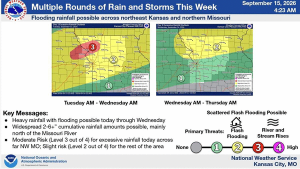
KANSAS CITY, Mo. — Flash and river flooding are possible as showers and thunderstorms spread across the Kansas City area Tuesday, bringing heavy downpours at times, according to the National Weather Service.
The heaviest rainfall is expected in northeast Kansas and northwest Missouri, where the ground is already saturated after heavy rain Tuesday morning. An additional 1 to 3 inches of rain is possible, with higher amounts in areas where storms repeatedly move over the same locations, the weather service said.
The National Weather Service has issued a flood watch that is in effect from 1 p.m. Tuesday through 1 p.m. Wednesday, including the Kansas City area.
The weather service said total rainfall of 2 to more than 6 inches of rain is possible, mainly north of the Missouri River. Most of the region faces a slight risk (Level 2 of 4) of excessive rainfall; a swath including the St. Joseph area faces a moderate risk (Level 3 of 4).
“Places in far NW MO and NE KS have already seen several inches of rain, making those areas more susceptible to flooding from subsequent storms,” the weather service said.
Runoff is expected to flow into creeks and streams, causing river levels to rise and currents to speed up. Urban areas and locations with poor drainage also could experience flooding, the weather service said.
There is also a marginal risk (Level 1 of 5) for strong to severe thunderstorms Tuesday evening, the weather service said. Damaging winds are the most likely hazard in strong to severe storms.
Temperatures are expected to vary widely across the region, with highs near 80 degrees expected in northwest Missouri and northeast Kansas and the mid- to upper 90s in central Missouri, where heat index values of 100 to 105 degrees are possible on Tuesday and Wednesday.
In Kansas City, temperatures are expected to reach about 91 degrees on Tuesday, above the metro area’s mid-September average of 80 degrees. The heat index is expected to climb into the upper-90s.
Storm chances are expected to linger through the week, with additional rain possible this weekend and into Monday evening. Drier weather is expected by early to midweek next week.
©2026 The Kansas City Star. Visit at kansascity.com. Distributed by Tribune Content Agency, LLC.






Comments