Subtropical Storm Josephine forecast to grow while NHC tracks 2nd Atlantic system
Published in Weather News
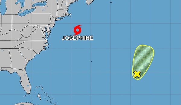
Subtropical Storm Josephine continued to surge off the U.S. Atlantic coast while the National Hurricane Center kept its eye on another system.
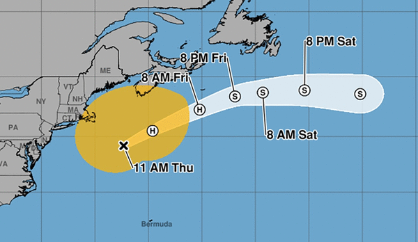
As of the 11 a.m. NHC advisory, Josephine was located about 200 miles southeast of Nantucket, Massachusetts and 420 miles south-southwest of Halifax, Nova Scotia moving northeast at 12 mph with maximum sustained winds of 65 mph.
Winds of 40 mph extend out up to 415 miles from the storm’s center.
“Some additional strengthening is forecast through the day today while Josephine begins to transition to an extratropical cyclone,” forecasters said. “Josephine is expected to become a powerful extratropical cyclone with hurricane-force winds by tonight or early Friday.”
The system is forecast to continue moving northeast before turning more to the east on Friday and into the weekend, away from land.
“On the forecast track, Josephine should move away from the United States and remain south of Nova Scotia andNewfoundland during the next couple of days,” forecasters said.
Although there are no coastal watches or warnings in effect, the storm’s proximity means high winds, dangerous surf and coastal flooding are possible over the next few days along portions of the U.S. East Coast.
Forecasters also are tracking a second system, a trough of low pressure located several hundred miles east-southeast of Bermuda in the subtropical central Atlantic producing a large area of disorganized showers and thunderstorms.
“Some development of this system is possible during the next day or two while it moves slowly north-northeastward,” forecasters said. “Upper-level winds are forecast to become too strong for further development by the weekend.”
The NHC gave it a 10% chance to develop in the next two to seven days.
So far, the 2026 hurricane season has produced nine named storms: Arthur, Bertha, Cristobal, Dolly, Edouard, Fay, Gonzalo, Hanna, Isaias and Josephine.
The next name on the list is Kyle.
Only Isaias has reached hurricane strength during what has been a very slow Atlantic season amid effects from a strong global El Niño weather pattern. Isaias made landfall on Oct. 9 near Destin on Florida’s Panhandle as a Category 2 hurricane.
Hurricane season began June 1 and runs through Nov. 30, but the height of hurricane season runs from mid-August through mid-October.
The National Oceanic and Atmospheric Administration in August had updated its seasonal forecast to expect between seven and 13 named storms this year. Of those, two to six would become hurricanes.
An average year would see 14 named storms and seven hurricanes, with three of those growing to Category 3 strength or higher.
©2026 Orlando Sentinel. Visit at orlandosentinel.com. Distributed by Tribune Content Agency, LLC.






Comments