Weather
/Knowledge
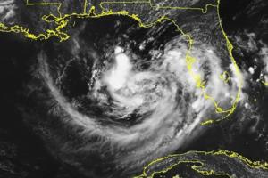
Bertha weakens to tropical depression hours after 2nd landfall, NHC says
Tropical Storm Bertha made its second landfall in two days after skirting Louisiana’s Gulf Coast and coming ashore near the border with Texas on Thursday, then weakened to a tropical depression, according to the National Hurricane Center.
The system made its first landfall Wednesday at 3 p.m. EDT with 45 mph sustained winds in St. Bernard ...Read more
Is recent rain enough to get rid of North Carolina's drought?
The Triangle is no longer in exceptional drought, the worst of the drought categories, after recent storms and rain brought some relief to dry conditions throughout the state.
Overall, just 2% of the state is now in exceptional drought, and about 9% of the state is considered “abnormally dry,” according to the latest report from the North ...Read more

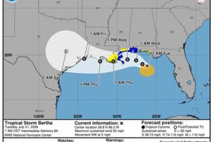
Tropical Storm Bertha makes 2nd landfall on Gulf Coast, NHC says
Tropical Storm Bertha made its second landfall in two days after skirting Louisiana’s Gulf Coast and coming ashore near the border with Texas on Thursday, according to the National Hurricane Center.
The system made its first landfall Wednesday at 3 p.m. EDT with 45 mph sustained winds in St. Bernard Parish near the Biloxi Wildlife Management ...Read more

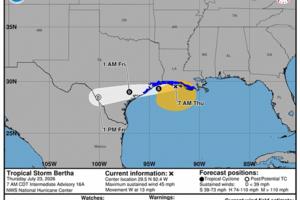
Tropical Storm Bertha nears 2nd landfall targeting Texas, NHC says
Tropical Storm Bertha continued to skirt Louisiana’s Gulf Coast on Thursday expected to keep its strength until making what would be its second landfall moving into Texas later in the day, according to the National Hurricane Center.
The system made its first landfall Wednesday at 3 p.m. EDT with 45 mph sustained winds in St. Bernard Parish ...Read more
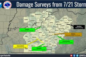
Officials confirm 6 Kentucky tornadoes, straight-line wind damage from severe storm
LEXINGTON, Ky. — Storm damage from six tornadoes and straight-line winds was found in several Kentucky communities during National Weather Service surveys on Wednesday.
NWS surveyors confirmed the tornadoes were on the ground in Bourbon, Carroll, Casey, Gallatin, Grant, Grayson, Hardin, Hart, Lincoln, Metcalfe and Owen counties during a ...Read more
Tropical Storm Bertha hugs Louisiana coast, targets Texas, NHC says
ORLANDO, Fla. — Tropical Storm Bertha continued to skirt Louisiana’s Gulf Coast on Thursday expected to keep its strength until moving into Texas later in the day, according to the National Hurricane Center.
The system made landfall Wednesday at 3 p.m. with 45 mph sustained winds in St. Bernard Parish near the Biloxi Wildlife Management ...Read more

Tropical Storm Bertha makes landfall on Gulf Coast, NHC says
Tropical Storm Bertha weakened Wednesday as it moved west along the Gulf Coast and made landfall in southeastern Louisiana, according to the National Hurricane Center.
The system moved ashore in St. Bernard Parish near the Biloxi Wildlife Management Area, according to a special 3 p.m. EDT update, still with 45 mph sustained winds and higher ...Read more
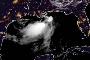
Tropical Storm Bertha slogs along just south of Gulf Coast, NHC says
ORLANDO, Fla. — Tropical Storm Bertha weakened Wednesday as it moved west along the Gulf Coast, but still with portions of Florida under tropical storm warnings, according to the National Hurricane Center.
As of the NHC’s 11 a.m. EDT advisory, the center of Bertha was located about 40 miles south of Pascagoula, Mississippi and 55 miles ...Read more

Heat wave smothering Southern California nears its peak
LOS ANGELES — A heat wave that's expected to rank among the hottest of the year so far will peak in Southern California on Thursday, with nights sultry enough to increase the risk of heat illness, as well as periods of critical fire weather, forecasters said.
Temperatures will be 8 to 12 degrees above normal, with muggy conditions limiting ...Read more

Tropical Storm Bertha slogs along Gulf Coast, NHC says
ORLANDO, Fla. — Tropical Storm Bertha weakened Wednesday as it moved west along the Gulf Coast, but still with portions of Florida under tropical storm warnings, according to the National Hurricane Center.
As of the NHC’s 5 a.m. advisory, the center of Bertha was located about 165 miles west-southwest of Panama City and 50 miles east-...Read more
Tropical Storm Bertha strengthens as warnings extend into Florida, NHC says
Tropical Storm Bertha strengthened Tuesday as it moved closer to the Gulf Coast, and the National Hurricane Center extended tropical storm warnings into Florida.
As of the NHC’s 8 p.m. EDT advisory, the center of Bertha was located about 120 miles west-southwest of Panama City and 105 miles south-southeast of Mobile, Alabama, moving west at 6...Read more

Tropical Storm Bertha strengthens as warnings extend into Florida, NHC says
Tropical Storm Bertha strengthened Tuesday as it moved closer to the Gulf Coast, and the National Hurricane Center extended tropical storm warnings into Florida.
As of the NHC’s 2 p.m. EDT advisory, the center of Bertha was located about 90 miles southwest of Panama City and 125 miles southeast of Mobile, Alabama moving northwest at 5 mph ...Read more

This SoCal heat wave could be hottest of the year: 5 things to know
LOS ANGELES — This week could bring Southern California its most sweltering temperatures of the year — a heat wave made all the more miserable, and dangerous, by oppressive muggy conditions and little nighttime relief.
"This looks to be the hottest stretch so far this year," said Ryan Kittell, a meteorologist with the National Weather ...Read more
Tropical Storm Bertha strengthens as it nears Gulf Coast, NHC says
ORLANDO, Fla. — Newly formed Tropical Storm Bertha strengthened overnight as it moved closer to the Gulf Coast on Tuesday, according to the National Hurricane Center.
As of the NHC’s 8 a.m. advisory, the center of Bertha was located about 100 miles south-southwest of Panama City and 175 miles southeast of Mobile, Alabama moving northwest at...Read more
Tropical Storm Bertha forecast to form today in Gulf, threaten Florida Panhandle, NHC says
ORLANDO, Fla. — A tropical depression in the Gulf is forecast to grow into Tropical Storm Bertha on Monday as it slowly moves toward the coast and could threaten the Florida Panhandle, according to the National Hurricane Center.
As of the NHC’s 8 a.m. advisory, the center of Tropical Depression Two was located about 110 miles south of ...Read more

Tropical storm watch in effect for Florida Panhandle as Tropical Depression Two forms
Tropical Depression Two formed Sunday morning from a low-pressure system near Florida’s Gulf coast, and it is forecast to become Tropical Storm Bertha within roughly 24 hours, forecasters said.
A tropical storm watch has been issued for Florida from Ochlockonee River to the Alabama border.
As of 11 a.m., the tropical depression was located ...Read more
Tropical Depression 2 forms off Florida coast, forecast to become Tropical Storm Bertha
Tropical Depression Two formed off Florida’s west coast Sunday, forecast to become Tropical Storm Bertha as it heads up to the Gulf Coast, according to the National Hurricane Center.
As of the NHC’s 11 a.m. advisory, the center of TD 2 was located about 155 miles south of Panama City moving north-northwest at 2 mph with maximum sustained ...Read more

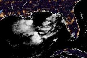
Odds increase system off Florida coast could become tropical, hurricane center says
ORLANDO, Fla. — The National Hurricane Center on Saturday said a system churning off Florida’s west coast has an increased chance to build into the season’s next tropical depression or storm.
In its 8 p.m. tropical outlook, the NHC said that satellite images and surface observations indicate a broad surface low has formed over the eastern...Read more

NYC hit with storms, flash floods, braces for gusts, hail, possible tornado
NEW YORK — After days of smoky skies and heavy heat, New York on Saturday was hit with “pea-sized hail” and flash flooding that saw numerous drivers swamped and trapped across the boroughs as severe weather hit the city.
New York City Emergency Management urged New Yorkers to stay inside as strong thunderstorms, possibly with quarter-inch...Read more

New York braces for thunderstorms, possible tornadoes after heat wave
NEW YORK — After days of smoky skies and heavy heat, New Yorkers on Saturday were once again bracing for severe weather, which is expected to include intense thunderstorms, isolated tornadoes, and hail.
“Thunderstorms are expected to bring damaging winds strong enough to down trees and power lines, along with heavy rainfall that could cause...Read more
Popular Stories
- Tropical Storm Bertha nears 2nd landfall targeting Texas, NHC says
- Tropical Storm Bertha makes landfall on Gulf Coast, NHC says
- Tropical Storm Bertha slogs along just south of Gulf Coast, NHC says
- Tropical Storm Bertha strengthens as warnings extend into Florida, NHC says
- Tropical Storm Bertha hugs Louisiana coast, targets Texas, NHC says
Comics