El Niño continues to strengthen. What does that mean for flood risk this winter?
Published in Weather News
The already strong El Niño conditions in the Pacific Ocean continue to grow stronger, federal scientists announced Thursday, with a 69% chance that this year’s event will be the strongest since modern records began in 1950.
Scientists at the National Oceanic and Atmospheric Administration in College Park, Maryland announced there is a 90% chance of a very strong El Niño through this fall and winter as water temperatures along the equator off South America continue to rise.
But while El Niño increases the odds of wet winters in California, it doesn’t mean what many people assume: That flooding is imminent later in the year for residents who live along rivers and creeks.
Of the 10 worst flooding years in California since 1950, ranked by dollar damage compiled by the California Office of Emergency Services, only three came during El Niño years.
Most of the worst — like in 2017, when downtown San Jose suffered $100 million in damage after Coyote Creek surged over its banks and 188,000 people were evacuated in the Sacramento Valley when the spillway at Oroville Dam collapsed — came when no El Niño conditions were present.
The reason? What matters most is not the total amount of rainfall in a year, experts say, but when it falls.
“Timing is everything,” said Jan Null, a meteorologist with Golden Gate Weather Services in Half Moon Bay who compiled 76 years of data on the pattern.
“Some people think there is a 1-to-1 relationship,” he said. “People equate El Niño with flooding in California. But that’s not always the case. Most of the worst flooding years weren’t El Niño years.”
When wet weather arrives, it takes time for watersheds surrounding lakes, rivers, and creeks to saturate and produce significant runoff. Water levels rise.
If storms are spread out, rivers and creeks have time to recede when the rain stops. But if several big storms come back-to-back-to-back, they continue to rise, and flooding occurs.
There have been four winters since 1950 with very strong El Niño conditions like this year. In 1982-83 and 1997-98, the Bay Area, Southern California and much of the state experienced double their average annual rainfall, with regular downpours and some flooding.
In another, 1991-92, the Bay Area was relatively dry, with 84% of normal rainfall, while Southern California was wet, with 133% and no major flooding in either area. And in the most recent — 2015-16 — the Bay Area had an average winter, and Southern California was drier than normal. Despite the event being heralded for months as a “Godzilla El Niño,” it was largely a bust, failing to end a prolonged drought.
Null cites 1997-98 as the classic example of why storm timing matters. That year, San Francisco was drenched with its second-wettest winter in history dating back to 1849, receiving 47 inches of rain, double its historical average. Other California cities received similar deluges. But flooding damage statewide was modest.
That winter ranked only 13th worst, with about $860 million in flood damage adjusted for inflation, compared to the $4.5 billion in 2022-23 when a mild La Niña — the opposite of El Niño, with cooler-than-normal ocean waters — was present.
“The storms were spread out in 1997-98,” Null said.
There were 119 days in 1997-98 when it rained, nearly double the historical average. Had the storms been more closely packed together, flooding could have been calamitous, he said.
California gets much of its annual rainfall in a dozen or fewer huge atmospheric river storms every year. These storms, vast plumes of water like rivers in the sky that come off the Pacific, have not been shown to be more frequent during El Niño winters, said Marty Ralph, director of the Center for Western Weather and Water Extremes at UC San Diego’s Scripps Institution of Oceanography.
“Atmospheric rivers don’t dance to the tune of El Niños,” said Ralph, one of the nation’s experts on such storms.
Ralph agreed that storm timing is critical for flood risk.
“When you get big storms in a brief period or close to each other, you get more flooding,” he said. “And often that’s multiple atmospheric rivers coming in a short time.”
Ralph noted that the wet winter of 2022-23, which broke a three-year drought and delivered a massive Sierra snowpack along with significant flooding around the state, was driven in large part by nine atmospheric river storms that hit California starting around Christmas, even though El Niño wasn’t present.
What does the record warm water off the equator now in an event some are calling a “Super El Niño” mean for this winter?
“It’s like playing a card game,” Ralph said. “The deck might be stacked. But it still might not work out. It’s an odds thing. The odds are stacked in favor of wet, but it could also go the other way.”
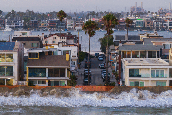
Ralph, Null and other experts say that El Niño conditions do raise the chances of significant flooding this winter along the coast. That’s because shifting winds that come with El Niño can push water eastward in the Pacific, and warmer ocean waters also expand, raising sea levels.
When storms combine with those conditions during high tides, it can cause significant coastal erosion and flooding in low-lying areas, including around San Francisco Bay.
“We’re expecting likely the highest sea levels ever recorded on the California coast,” said Mark Merrifield, director of the Center for Climate Change Impacts and Adaptation at the Scripps Institution of Oceanography, during a virtual town hall Aug. 4. “As a sort of unlucky coincidence, the tidal cycle is also going to be at a peak around the end of this year.”
Some scientists are sounding the alarm for both coastal and inland flooding.
Daniel Swain, a climate scientist with the University of California Agriculture and Natural Resources division, said he has been suggesting to family and friends that they buy flood insurance if they are located in areas that have potential flood risk and haven’t already. He noted supercomputer climate models, particularly the European model, show a high likelihood of wet conditions this winter.
“There’s no guarantee, although the coastal flooding is about as close to a guarantee as we can get,” Swain said, calling the current warming trend in the Pacific “frankly pretty extraordinary.”
“The inland flooding is a bigger wild card,” Swain added. “But I do think the odds of a very wet winter in California this year, and therefore the odds of significant flooding, are significantly higher than they would usually be.”
_____
©2026 MediaNews Group, Inc. Visit at mercurynews.com. Distributed by Tribune Content Agency, LLC.






Comments