Weather
/Knowledge
Colorado power outages disrupt atomic clock in Boulder
Power shut off across Colorado last week as hurricane-force winds swept across the state. In Boulder, one of those outages caused time to briefly stand still.
The National Institute of Standards and Technology’s Internet Time Service Facility in Boulder lost power Wednesday afternoon, disrupting the agency’s atomic clock, spokesperson ...Read more
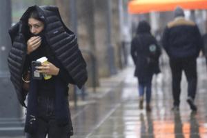
Southern California's Christmas weather forecast keeps getting worse. What you need to know
LOS ANGELES — The Pineapple Express storm bearing down on Southern California could bring heavy rain and strong winds throughout Christmas week, potentially triggering mudslides, downing trees and flooding not only freeways but also homes and businesses.
If the forecasts are right, this could be one of the stormiest Christmases in recent ...Read more
California in for wet, white, potentially wild Christmas as Pineapple Express storm looms
A powerful Pineapple Express storm could deliver a wet, white and potentially wild Christmas to California, with the possibility of snow in the Sierra Nevada and plenty of rainfall across Southern California.
The incoming atmospheric river system is shaping up to be the strongest in years to hit the Los Angeles area on the holiday — and ...Read more
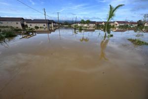
Jamaica's road to recovery after Hurricane Melissa requires international help, UN says
Six weeks after Hurricane Melissa made landfall in Jamaica and left behind an unprecedented trail of destruction, hundreds of people remain unable to return home, while many others are still without electricity.
Dennis Zulu, the United Nations resident coordinator for the country and several others Caribbean islands, said Wednesday that while �...Read more
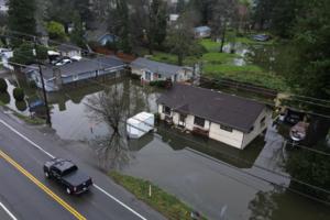
Hundreds of thousands out of power in Washington state; blizzard warning continues
SEATTLE — A storm brought high winds and heavy rain to Western Washington overnight into Wednesday, leaving more than 200,000 customers in the dark after days of flooding.
Wind speeds reached the 50s and 60s in Seattle and surrounding areas early Wednesday: In the Alpental Ski Area, 112 mph gusts were recorded around 2 a.m., and Snoqualmie ...Read more

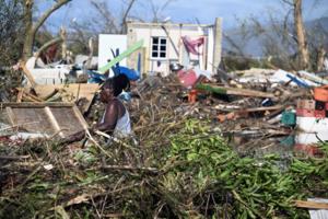
Jamaica tourism reopens after devastating Hurricane Melissa. It wasn't easy
Three weeks after Jamaica was battered by the worst hurricane to hit the island on record, roads were still clogged with debris, thousands remained without electricity, and at Jakes Hotel on the island’s hard-hit Treasure Beach, brother and sister Jason and Justine Henzell were in a quandary.
As they worked to help farmers and fishermen in ...Read more
Big rain and snow could hit California around Christmas, risking floods, landslides and snarling travel
LOS ANGELES — Big rain and snow could hit California around Christmastime, ending a long dry spell for the state.
There's a high risk for heavy rainfall along the entire California coast between Dec. 23 through Christmas Day, the National Oceanic and Atmospheric Administration's Climate Prediction Center said. There's also a high risk of ...Read more

Washington weather: More rain, wind forecast; flood warnings still in effect
Rain showers hit Western Washington Monday morning as another atmospheric river drenches the state.
The National Weather Service said Monday that the storm will continue through Wednesday, with about 2 to 4 inches of rain expected in foothill areas and 4 to 6 inches on higher ground. That will likely shift to snow in the mountains, including in...Read more
Another atmospheric river is headed to Western WA, but it won't be as bad
SEATTLE — As Western Washington reels from catastrophic flooding that swept the areas along major river valleys, another plume of moisture will arrive on Sunday, according to the National Weather Service.
An atmospheric river rolled into the region Monday, bringing devastating floods to several areas and hitting communities along the Nooksack...Read more
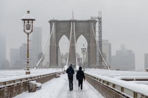
NYC to get up to 4 inches of snowfall overnight
NEW YORK — New York City is poised for a wintry glow-up overnight, with several inches of snow forecast to fall across the five boroughs as Christmas draws ever near.
While Saturday started off unseasonably warm — with highs hitting the low 40s — temperatures are expected to dip just enough by late evening, setting the stage for a snowy ...Read more
For livestock owners in Washington's floods, evacuating is extra complicated
SEATTLE — As flood warnings got more serious on Monday evening, Kim Head knew she had to pack up her horses and leave.
The Snohomish County resident, who lives outside Monroe, had 14 horses to move as river predictions climbed and floods threatened the property.
Gathering some friends and people who board their horses on her property, Head ...Read more
Trump signs emergency declaration for Washington floods
SEATTLE — President Donald Trump has granted Washington’s request for an emergency declaration in response to this week’s devastating flooding, according to Gov. Bob Ferguson.
Ferguson said he received a phone call from Secretary of Homeland Security Kristi Noem informing him of the president’s decision and that the state has also ...Read more
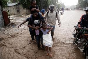
Haiti farmers battered by Hurricane Melissa are still reeling, UN says
A month and a half after Hurricane Melissa killed dozens of people in Haiti, the country is still struggling with its aftermath.
Haitians, who were already going hungry because gang violence has blocked highways and cut off commerce, are grappling with even more shortages and the loss of crops, the regional director of the United Nations’ ...Read more
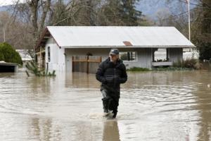
Washington floods: Dozens rescued while stranded in homes, vehicles
SEATTLE — Rescue crews saved dozens of people Thursday as historic flooding and heavy rains swept through Western Washington.
Those living near the Snohomish and Skagit rivers face the brunt of record flooding described as potentially “catastrophic” by the National Weather Service.
“This situation is dynamic and dangerous,” Snohomish...Read more

Washington flooding a state of emergency, governor says
CAMP MURRAY, Wash. — Gov. Bob Ferguson declared a state of emergency Wednesday, called in the National Guard and said he is requesting assistance from the federal government following historic flooding that continues in Western Washington this week.
The governor made the announcement during a news conference at the state emergency operations ...Read more
'A bit like poker,' California's wet winter brings La Niña/El Niño confusion
LOS ANGELES — Californians can be excused for being confused about the weather forecast.
Scientists in October said La Niña had arrived, which many associate with dry conditions, particularly in the Southland.
But we have instead experienced a very wet season — at least so far — with rain bringing much-needed moisture to the brush, ...Read more

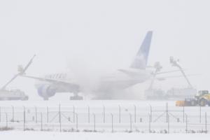
More than 900 flights delayed by snow at Denver International Airport
More than 900 flights were delayed Wednesday at Denver International Airport as a winter storm dumped several inches of snow on the metro area.
As of 6:45 p.m. Wednesday, 939 flights at DIA were delayed and 11 were canceled, according to flight-tracking website FlightAware.
Flights headed in and out of DIA were being delayed by an average of ...Read more
Snow delays hundreds of flights at Denver International Airport
DENVER — Hundreds of flights were derailed Wednesday morning at Denver International Airport during a weather-fueled ground delay issued by the Federal Aviation Administration.
As of 7 a.m. Wednesday, 267 flights at DIA had been delayed and one was canceled, according to flight-tracking software FlightAware.
Flights headed in and out of DIA ...Read more

First winter storm of the season dumps snow on upstate NY
NEW YORK — The first major winter storm of the season struck upstate New York on Tuesday, with much of the region forecast to receive some significant snowfall by day’s end.
Precipitation from a “strengthening coastal storm” started falling overnight, first as a wintry mix, then as tendrils of snow Tuesday morning, at times falling at a...Read more
Billions of dollars being provided to help Jamaica recover from Hurricane Melissa
A month after Hurricane Melissa devastated Jamaica and left billions of dollars in damage in its wake, international financial institutions are making up to $6.7 billion available to help the island-nation in its recovery and reconstruction.
The funds, available over three years, are part of a financial support package put together by the ...Read more
Popular Stories
- Colorado power outages disrupt atomic clock in Boulder
- Southern California's Christmas weather forecast keeps getting worse. What you need to know
- California in for wet, white, potentially wild Christmas as Pineapple Express storm looms
- Jamaica's road to recovery after Hurricane Melissa requires international help, UN says
- Jamaica tourism reopens after devastating Hurricane Melissa. It wasn't easy
Comics