Weather
/Knowledge

Dramatic weather shift brings significant Southern California cooldown, possible rain
LOS ANGELES — March in Southern California has been marked almost entirely by unusually warm temperatures, but the month is set to close out with a cooler spell.
A dramatic shift in weather will drop temperatures across the region this week and bring a slight chance of rain — a pattern more typical for early spring than the summer-like ...Read more

Staying hot: Las Vegas to endure more record heat this weekend
LAS VEGAS — Tired of the spring Las Vegas heat? You’re in luck because a major cooldown is on the way. But not until next week.
Expect more record-breaking temperatures this weekend as the historic March heat wave begins to wane. Daytime forecast highs for Saturday and Sunday will be in the low 90s. Saturday’s record high is 91 (set in ...Read more

El Niño is on the way: What that means for California's weather
SAN JOSE, Calif. — Earlier this month, scientists at NOAA, the National Oceanic and Atmospheric Administration, issued an “El Niño Watch” for this summer. They said there is a 62% chance that El Niño conditions will appear from June through August, growing to 83% by October.
That triggered a lot of hype about “Super El Niños,” “...Read more

Up to 5 storms predicted to impact US in AccuWeather hurricane season forecast
Despite a prediction of a slow hurricane season, up to five tropical systems could still make an impact on the United States this year, according to the forecast released Wednesday by AccuWeather.
One of the first annual prognostications for the season, which officially runs June 1-Nov. 30, calls for 11 to 16 named storms — of which four to ...Read more
Why hurricane season could bring fewer but stronger storms. See predictions
MIAMI — Strong winds across the Atlantic could make it harder for storms to form, potentially pushing the 2026 hurricane season below average, according to AccuWeather’s newly released forecast.
The forecasting service predicts 11 to 16 named storms, including 4 to 7 hurricanes and 2 to 4 major hurricanes.
Last year, AccuWeather’s 2025 ...Read more

US Southwest heat wave tumbles records, raises fire risk
Nearly 9.5 million people across the U.S. Southwest face extreme high temperatures, as an ongoing heat wave continues to topple records and raise the risk of wildfires as far away as the Great Plains.
Las Vegas reached 96F Saturday, a record for the date, while the nearby local National Weather Service office hit 97F for the second day in a row...Read more

Colorado weather: Record-breaking heat, fire danger returns to Front Range
DENVER — Colorado is seeing another day of record-breaking heat and dangerous fire weather on Saturday before a slight cool-off is set to begin Sunday, according to the National Weather Service.
Denver quickly broke the daily high temperature record on Saturday, with mercury at the airport hitting 81 degrees by 11:05 a.m. and still rising. ...Read more
Hawaii hit with more flooding as heat tops records in West
Heavy rains were being dragged across Hawaii by a “Kona low” for the second time in two weeks, prompting residents to flee their homes and closing roads across the island chain.
Evacuations were ordered in the Waialua and Haleiwa sections of northwest Oahu after flooding threatened a dam in the area, the Hawaii Emergency Management Agency ...Read more

Why unprecedented March heat wave in California has experts worried about what comes next
LOS ANGELES — The most destructive wildfires in Southern California history. The region's wettest holiday season. The hottest March heat wave on record.
In the last 15 months, the Southland has seen a trio of extreme weather events, and UC climate scientist Daniel Swain says there's one clear through line connecting them all.
"All of the ...Read more

What does the March heat wave mean for California's fire season?
SAN JOSE, Calif. — The five-day heat wave that broke records across California and the West this week is winding down, with temperatures in the Bay Area forecast to fall from the 90s to the 70s in many places over the weekend.
But the effect of the overall hot, dry month of March is likely to be felt all summer, experts say, through increased...Read more

Dozens of temperature records shattered across SoCal as historic March heat wave sizzles on
LOS ANGELES — Southern California is gearing up for a third straight day of record-breaking temperatures as an unusually long and strong March heat wave pushes the mercury up to 35 degrees above normal.
L.A. and Ventura counties broke more than a dozen daily temperature records Tuesday when Woodland Hills reached 101 degrees, Burbank hit 99 ...Read more

Ice builds as Michigan endures historic blizzard
TRAVERSE CITY, Mich. — A historic storm that dumped more than 4 feet of snow on parts of Michigan's Upper Peninsula tapered off Tuesday, but ice accumulated in northeastern lower Michigan and other locations as more than 90,000 people still lacked power, and some roads remained impassable.
A station near Round Lake in the U.P.’s Luce County...Read more

Historic Michigan blizzard prompts emergency declaration by Gov. Whitmer
LANSING, Mich. — Citing extreme winter weather, Michigan Gov. Gretchen Whitmer declared Tuesday a state of emergency in seven counties and a statewide energy emergency.
A winter storm system on Sunday and Monday dropped 2 feet to 4 feet of snow across much of Northern Michigan and the Upper Peninsula, causing widespread damage, according to ...Read more
Damaging winds top over 80 mph, leave tens of thousands without power in New England
BOSTON — Gusty winds barraged Eastern Massachusetts and New England through Monday night, reportedly bringing over tens of thousands of power outages and gusts up to 80 mph.
“Overnight, the majority of the worst of it was after midnight,” said NWS meteorologist Emily McMinn. “It was between midnight and 3 a.m. Eastern Massachusetts ...Read more

As snow and wind taper off, thousands still without power after historic storm hits Michigan
Traverse City — More than 105,000 customers were without power in Michigan Tuesday morning after a historic blizzard dumped more than 30 inches of snow in some places, closing schools for a second day and continuing to make roads impassable.
Southeast Mount Arvon area in the Upper Peninsula's Baraga County appears to have broken the one-day ...Read more

California's snowpack was already meager. Now comes an extraordinary heat wave
The warm winter has left very little snow in California’s Sierra Nevada, and now an extreme heat wave is accelerating the rapid melt in the mountains.
The Sierra snowpack measures 45% of average for this time of year, according to state data, down from 73% of average in late February.
When water expert Newsha Ajami went skiing near Lake ...Read more
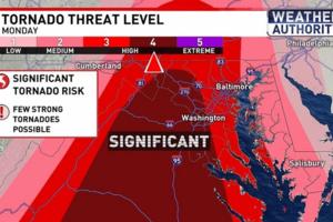
Incoming storms prompt early school dismissals as Maryland braces for damaging winds
BALTIMORE — A powerful storm system expected to move across Maryland on Monday could bring damaging winds, heavy rain, hail and possible tornadoes, prompting Gov. Wes Moore to declare a state of preparedness and local school systems to announce early dismissals.
The National Weather Service forecasted rain and possible thunderstorms before 4 ...Read more

More than 131,000 without power as major storm hits northern Michigan
TRAVERSE CITY, Mich. — More than 2.5% of electrical customers in Michigan were without power Monday morning as winter storms pummeled the northern half of the state and the Upper Peninsula.
The state as of 9:25 a.m. had more than 131,000 power outages recorded. Consumers Energy, which serves much of lower Michigan outside of the eastern side ...Read more

Boston Weather: Flooding, high winds warnings incoming
Potential flooding and high winds are set to kick off the week for Boston, before a period of chillier dry weather heading into next weekend, according to National Weather Service Forecasts.
“Rain starts to move in, heading into (Monday) morning,” said NWS meteorologist Candice Hrencecin. “(Monday) is going to be pretty rainy. And then it...Read more
Popular Stories
- Dramatic weather shift brings significant Southern California cooldown, possible rain
- Staying hot: Las Vegas to endure more record heat this weekend
- El Niño is on the way: What that means for California's weather
- Dozens of temperature records shattered across SoCal as historic March heat wave sizzles on
- More than 131,000 without power as major storm hits northern Michigan
Comics