Hurricane center tracks 3 systems again; 1 with high chances to become tropical depression
Published in News & Features
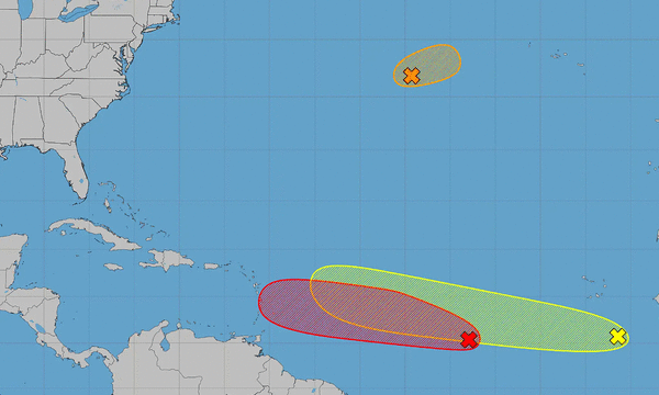
ORLANDO, Fla. — The National Hurricane Center on Wednesday was busy keeping track of three systems including one with a high chance to develop into the season’s next tropical depression or storm.
As of the NHC’s 8 a.m. tropical outlook, the most threatening is a tropical wave about 900 miles west-southwest of the Cape Verde Islands in the central tropical Atlantic with more organized showers and thunderstorms since Tuesday.
“Environmental conditions are forecast to be conducive for development during the next few days, and a tropical depression will likely form within a couple of days while the system moves westward to west-northwestward across the central tropical Atlantic,” forecasters said.
The NHC gave it a 80% chance to develop in the next two days and 80% in the next seven.
If it were to grow into a named system, it could become Tropical Storm Cristobal.
On its tail in the eastern tropical Atlantic is another tropical wave just offshore of the coast of west Africa with disorganized showers and thunderstorms.
“Environmental conditions are forecast to be generally conducive for some development of this system during the next several days while it moves westward or west-northwestward across the eastern and central tropical Atlantic,” forecasters said.
The NHC gives it a 20% chance to develop in the next two days and 30% in the next seven.
Forecasters also continue to track a system to the north in the central subtropical Atlantic, located about 1,000 miles east-northeast of Bermuda and moving away from the U.S. Satellite images indicate it has developed gale-force winds.
“However, the circulation is elongated and the associated convection has become a less organized during the past few hours,” forecasters said. “Some development of this system is possible through tonight, and a short-lived tropical storm could form while it moves eastward to east-northeastward at around 20 mph across the central subtropical Atlantic.”
It’s forecast to move into cooler waters by Thursday, which would end any chances of formation.
The NHC gave it a 50% chance to develop in the next two days.
So far the 2026 Atlantic hurricane season, which began June 1 and runs through Nov. 30, has been slow with only two named systems – tropical storms Arthur and Bertha.
After Cristobal, the next names on the list are Dolly and Edouard.
The National Oceanic and Atmospheric Administration last week updated its seasonal forecast stating it expects between seven and 13 named storms this year. Of those, two to six would become hurricanes. It also predicted that there might not be any major hurricanes this year, or at most two.
Already 2026 was forecast to have lower-than-average storm generation, and that has been reduced even further with the latest forecasts from the NOAA and other weather groups.
An average year would see 14 named storms and seven hurricanes, with three of those growing to Category 3 strength or higher.
The height of hurricane season, though, has yet to begin, running between mid-August and mid-October.
-------------
©2026 Orlando Sentinel. Visit at orlandosentinel.com. Distributed by Tribune Content Agency, LLC.






Comments