Colorado wildfires: Uncontained fires scorch nearly 90,000 acres, 'critical fire weather' forecast
Published in News & Features
DENVER — Large wildfires burning across southern and western Colorado continued to spread on Tuesday, together scorching nearly 90,000 acres — roughly 140 square miles.
“Critical fire weather” — hot, dry and windy — is expected each day this week and could spur the growth of existing and new wildfires across the state, according to the National Weather Service.
As of Tuesday morning, red flag warnings had been issued for Boulder, Chaffee, Clear Creek, Crowley, Douglas, El Paso, Fremont, Gilpin, Grand, Huerfano, Jackson, Jefferson, Larimer, Las Animas, Otero, Park, Pueblo, Summit and Teller counties. Most warnings will be active from noon to 9 p.m., with some expanded warnings for southern Colorado ranging from 10 a.m. to 10 p.m.
Red flag warnings were also issued for the Colorado River Basin and Gunnison Basin, according to the weather service.
“Conditions will be favorable for rapid fire spread,” forecasters wrote in the warnings. “Avoid outdoor burning and any activity that may produce a spark and start a wildfire.”
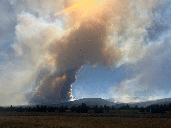
Snyder fire in Mesa County and Utah
Colorado’s largest wildfire was burning on more than 30,000 acres along the Colorado-Utah border on Monday, according to fire officials.
The Snyder fire — a conglomeration of Utah’s Snyder Mesa and Jones fires and Colorado’s Knowles and Gore fires in Mesa County — has scorched 30,209 acres with no containment and has killed three firefighters and injured two others, according to a Monday evening update from fire officials.
The two Utah fires spread into Mesa County on Saturday, prompting Colorado Gov. Jared Polis to issue a disaster declaration as they merged and consumed the two Colorado fires. The rapidly growing blaze then overtook five firefighters from the Rifle Helitack who were responding to the Colorado wildfires.
The five were trying to deploy their tent-like shelters when they were overcome, officials announced at a news conference on Monday.
U.S. Forest Service officials identified the firefighters who died as 38-year-old Emily Barker of Michigan, 27-year-old Nick Hutcherson of Arizona and 27-year-old Sydney Watson of Alabama. An investigation has been opened into their deaths, federal officials said.
Two other firefighters sustained burn injuries and remained hospitalized Monday in the Denver area, officials said during the news conference.
It’s unknown when the fire was last mapped and how much of the damage is in each of the two states, but fire maps appear to show most of the burn area on the Western Slope.
As of Tuesday, the fire had burned across the mesa tops and reached the edge of canyons in the area, according to officials with Rocky Mountain Complex Incident Management Team 1. That includes McInnis Canyon, a natural conservation area near Fruita, according to Colorado Parks and Wildlife.
The state wildlife agency shut down the boat ramp at the Fruita section of James M Robb Colorado River State Park “for the safety of firefighters and the public,” agency officials wrote in the closure alert.
“We cannot emphasize this enough: if you are floating the Colorado River, please end your trip at the Fruita boat ramp or a boat ramp farther upstream,” CPW Northwest Region Manager Travis Black said in a statement. “We ask that everyone respect these closures, not only for your own safety but also to protect the firefighters and emergency responders working diligently on the ground.”
Pre-evacuation notices were issued on Sunday for residents living in the Glade Park area, the Kingsview subdivision and the Pollock Canyon Estates, according to the Mesa County Sheriff’s Office. That includes the area south of the Colorado River to BS Road and west of Colorado 340. The sheriff also closed A 2/10 Road at DS Road and BS Road before the Bureau of Land Management boundary, the Kokopelli Trail Road between Loma and Mack and 16 5/10 Road to Glade Park at Monument Road and Rim Rock Drive, according to law enforcement.
The sheriff’s office and the American Red Cross are operating a Snyder Mesa fire evacuation center at Grand Junction High School, 1400 N. Fifth St.
Gold Mountain fire near Ouray
The Gold Mountain fire sparked Saturday north of Ouray, forcing evacuations. It was first mapped at an acre on Saturday, grew to 4,217 acres by Sunday evening and had charred 7,103 acres as of Monday, according to the Colorado Division of Homeland Security and Emergency Management.
By Tuesday morning, the wildfire was estimated to have consumed 8,277 acres. That’s roughly 13 square miles.
Colorado Gov. Jared Polis issued a disaster declaration for the Gold Mountain fire — which forced evacuations north of Ouray — on Sunday.
Mandatory evacuations included residents in and near Lake Lenore, Panoramic Heights, Redstone Road and Peck’s Trailer Park, as well as those living between the trailer park and Cedar Hill Cemetery, according to the Ouray County Sheriff’s Office. Pre-evacuation notices were also issued for residents living on Ouray County Road 17 from the Whispering Pines area to the Black Lake area.
An evacuation shelter was opened at the Ridgway Secondary School, 1200 Green Street, according to county officials.
As of Tuesday morning, U.S. 550 remained closed in both directions between 10th Avenue and Ouray County Road 23 for the fire, according to the Colorado Department of Transportation.
Ferris fire in San Juan National Forest, near Dolores
The Ferris fire, which started Saturday as three separate fires in southwestern Colorado’s San Juan National Forest, has consumed nearly 20,000 acres with no containment, according to federal officials.
As of Tuesday morning, the lightning-sparked wildfire was estimated to be burning on 19,613 acres, according to fire officials. That’s just over 30 square miles. Officials previously said the fire had grown to 20,561 acres, or 32 square miles, but updated the size estimate after receiving more accurate infrared mapping.
Crews were told to expect a “challenging” day during Tuesday’s morning briefing, according to an update from the incident management team.
“Strong winds, progressing throughout the day, are expected to gust up to 55 mph,” the update stated. “Combined with low relative humidity and extremely dry fuels, the fire can quickly turn volatile.”
The Ferris, Far Draw and Doe fires — now called the Ferris fire — started in the San Juan National Forest’s Glade area near Narraguinnep Canyon, north of Dolores, according to the Forest Service.
Mandatory evacuations were issued for residents north and east of the wildfires, according to the Dolores County Office of Emergency Management. The evacuation area was bordered to the north by Disappointment Road, to the south by the Glade Ranch community, to the west by the fire and to the east by Road 30, according to the office.
Strong winds are expected Tuesday, but fire crews will directly engage the fire where they can safely do so to stop its forward progress and protect homes and private property, Ferris fire officials said.
The U.S. Forest Service also closed the Bradfield Bridge Campground, Forest Service Road 504 to the base of McPhee Dam, Forest Service Road 521 and Forest Service Road 504 “out of an abundance of caution,” federal officials said.
Colorado Parks and Wildlife on Tuesday cut off public access to the Lone Dome State Wildlife Area in Dolores and Montezuma counties, according to a news release from the agency. As fire conditions continue to change, further closures may be put into place for public safety and to support firefighting efforts, wildlife officials said.
“We’re implementing the closure to support the efforts by the U.S. Forest Service and the counties to keep the public out of the active fire area and to protect public and firefighter safety,” CPW Area Wildlife Manager Adrian Archuleta stated in the release. “We appreciate the public’s assistance in respecting these closures.”
Willow fire near Leadville
The Willow fire sparked Sunday evening near the Leadville National Fish Hatchery and quickly grew across more than 1,900 acres, prompting evacuations for residents west of town.
The wildfire was first reported at about 4:20 p.m. Sunday by the Lake County Office of Emergency Management. At that time, it was burning on a handful of U.S. Forest Service acres below Mount Massive, near Twin Mounds, county officials said.
By Tuesday morning, the fire had spread to an estimated 1,919 acres with no containment in the San Isabel National Forest, according to the Colorado Division of Homeland Security and Emergency Management. That’s roughly 3 square miles.
Colorado Gov. Jared Polis issued a disaster declaration for the fire on Monday.
As of Tuesday morning, the mandatory evacuation area included Turquoise Lake and was bordered to the south by Rock Creek, to the west by Hagerman Pass, to the north by Galena Mountain and to the east by Leadville, according to the Lake County evacuation map. The Leadville area and homes north of the fire along U.S. 24 were on pre-evacuation status at that time.
Lake County officials said evacuations included all residents on County Road 4 east to County Road 9D, County Road 9, County Road 9D, County Road 5A, County Road 48, County Road 99, all trails from the Leadville National Fish Hatchery, all campgrounds around Turquoise Lake, the Colorado Trail and Hagerman Pass into Pitkin County.
The cause of the fire remains under investigation.
Aspen Acres fire in Custer and Pueblo counties
Driven by 100 mph winds, a wildfire that sparked Monday morning in in southern Colorado exploded in size, racing across more than 28,000 acres — roughly 44 square miles — and forcing evacuations, according to the Pueblo County Sheriff’s Office.
As of Tuesday morning, the 28,314-acre Aspen Acres fire was the second-largest wildfire burning in Colorado — behind the fatal, more than 30,000-acre Snyder fire — despite its short lifespan. Its burn area grew by more than 5,000 acres, or 8 square miles, overnight.
The extreme winds made it impossible for crews to provide aerial support, Pueblo County sheriff’s officials said Monday. An unknown number of structures were affected by the fire, according to the agency.
Authorities have ordered mandatory evacuations in the Beulah, Rye, San Isabel Lake, Aspen Acres, Lazy Acres and Bishops Castle areas, as well as for Colorado 165 from Colorado 96 south to the Pueblo County line, 3R Road to Waterbarrel Road and South Burnt Mill Road to Interstate 25, about 2 miles south of Pueblo’s Southgate area.
Evacuated residents can seek shelter at the Pueblo County Recreation Center, 1650 Cooper Place, or the Wetmore Community Center, 95 County Road 393.
The wildfire, for which Colorado Gov. Jared Polis has issued a disaster declaration, was reported as a spot fire near the Aspen Acres campground shortly before 6 a.m. Monday. It grew to 362 acres by 10 a.m., reached 2,476 acres around noon and exploded in size to 22,827 acres Monday evening, according to fire officials.
The fire made an 8-mile run off of timber in the foothills and is burning east through “extremely dry grass and brush,” according to a Tuesday morning update from the Colorado Type 3 Incident Management Team, which has taken the lead on this wildfire.
“Extreme fire behavior is likely as the day heats up and the winds increase,” fire officials stated in the update.
The Federal Emergency Management Agency on Monday night authorized the use of federal funds to help with the firefighting costs in southern Colorado, according to a news release from the agency.
FEMA officials ruled that the Aspen Acres fire “threatened such destruction that it would constitute a major disaster,” according to the agency. As of Monday night, the fire was threatening more than 1,200 homes, which had been evacuated.
Federal funding will cover 75% of the state’s eligible firefighting costs under an approved grant for managing, mitigating and controlling designated fires, according to the federal agency. Eligible expenses can include field camps; equipment use, repair and replacement; mobilization and demobilization activities; and tools, materials and supplies.
Air quality alerts
As wildfires continue to burn across Colorado, state health officials have issued another air quality advisory for parts of the mountains and Western Slope.
The newest alert from the Colorado Department of Public Health and Environment will remain in effect until at least 9 a.m. Wednesday, according to the agency.
Smoke could create unhealthy conditions near and downwind of the fires burning in southwestern Colorado and southeastern Utah, including in Chaffee, Clear Creek, Custer, Delta, Dolores, Eagle, Elbert, El Paso, Fremont, Garfield, Gilpin, Grand, Gunnison, Huerfano, Jackson, Lake, Lincoln, Mesa, Moffat, Montezuma, Montrose, Morgan, Ouray, Park, Pitkin, Pueblo, Rio Blanco, Routt, Saguache, San Miguel, Summit, Teller and Washington counties, according to state health officials.
If the smoke drops visibility to less than 5 miles in an area, it has reached unhealthy levels, according to the agency. Those with heart disease and respiratory illnesses, young children and older adults are more at risk.
----------
©2026 MediaNews Group, Inc. Visit at denverpost.com. Distributed by Tribune Content Agency, LLC.


Comments