Current News
/ArcaMax

Germans mourn Berlin Pride attack seen as Islamist terror
Germans were left in shock and mourning on Sunday after what authorities called an Islamist terror attack on one of Europe’s largest LGBTQ events.
Hundreds of people flocked on Sunday evening to the Tiergarten, the central city park where Abdul Ballout has been accused of driving a van into a crowd of people on the sidelines of the Pride ...Read more
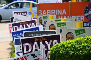
Maryland's campaign season leaves behind a mountain of waste
Every election season, Maryland political campaigns blanket voters with paper mailers, plastic yard signs and campaign literature. After the votes are counted, much of that material becomes trash — waste that few agencies track and almost no candidates campaign on reducing.
Some ends up in landfills or is burned at trash incinerators, while ...Read more

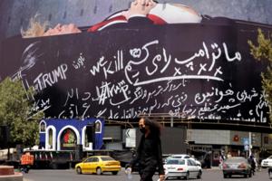
US, Iran extend pause in strikes as Oman holds new Hormuz talks
The U.S. paused an almost two-week run of strikes against Iran for a second night while the Islamic Republic signaled it was refraining from any retaliatory attacks and held talks with Oman over the Strait of Hormuz.
After striking Iran for 13 days, the U.S. has apparently held off since late Friday without any explanation or announcement, ...Read more

As Las Vegas grows, Clark County looks to protect its burrowing owls
Before Rick Walker retired and became an owl monitor at the Rainbow Owl Preserve in the northwest valley, he was a dentist in New Orleans.
Walker said there’s a common thread between the two pursuits: watching his patients and the western burrowing owls grow up.
“It was great because you got to see families grow up,” he said. “Same ...Read more
US, Iran extend pause in strikes as Oman holds new Hormuz talks
The U.S. paused an almost two-week run of strikes against Iran for a second night while the Islamic Republic signaled it was refraining from any retaliatory attacks and held talks with Oman over the Strait of Hormuz.
After striking Iran for 13 days, the U.S. has apparently held off since late Friday without any explanation or announcement, ...Read more

Germany calls Berlin Pride attack an act of Islamist terror
German police fanned out in pursuit of the suspect in a deadly van ramming at Berlin’s Pride festival on Saturday night that authorities called an Islamist terror attack.
Speaking at a press conference, Interior Minister Alexander Dobrindt identified the fugitive as German-born Abdul Ballout, 21, a citizen whose mother was naturalized in ...Read more

Modi punctured as awakened India students force retreat
For much of Narendra Modi’s 12 years ruling India, he’s looked nearly unbeatable at the polls. This weekend he swiftly yielded to a group that didn’t exist a few months ago, energizing opponents who have struggled to rattle one of the nation’s most powerful leaders ever.
Education Minister Dharmendra Pradhan resigned on Saturday to take...Read more
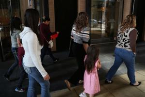
'Deportation factory': Chicago's immigration court epicenter for US spike in removal orders, analysis shows
CHICAGO — On a May morning, Immigration Judge Peter Kim’s Loop courtroom offered a scene that would help explain how Chicago would soon lead the nation in deportation orders.
In notes kept by a volunteer group of court observers, they described an overflowing courtroom, with people standing two rows deep up to an interpreter’s desk. One ...Read more

Mayor Mamdani's vision for NYC school integration is broader than admissions reforms
As he prepared to take office, Mayor Zohran Mamdani made national headlines about whether he could revive integration efforts in New York City’s public schools.
Those questions resurfaced this month after the incoming classes at the specialized high schools — eight competitive public schools that admit students based on the results of one ...Read more
Mural at site of Jewish temple that burned in Eaton fire vandalized with swastikas, antisemitic graffiti
LOS ANGELES — Authorities are investigating a hate crime after a beloved Pasadena mural was vandalized this week with an antisemitic message and swastikas.
The incident took place Friday on the 1400 block of North Altadena Drive in the unincorporated area of Pasadena, according to the Altadena Sheriff’s Station. It was unclear to ...Read more

Australian Prime Minister Albanese to press Trump on new tariffs
Australian Prime Minister Anthony Albanese said he will appeal directly to President Donald Trump over new tariffs announced by Washington, describing the levies as unjustified.
Albanese said he would “absolutely” raise the topic with Trump, when asked during an interview on ABC’s Insiders program on Sunday. The Trump administration ...Read more

LA's dangerous game of triage as aging water system hits breaking point
LOS ANGELES — The Los Angeles water system is so old — and money for replacements is exceedingly scarce — that officials are left playing a dangerous game of triage.
They know huge swaths of the system are in desperate need of replacement. But with limited time and money, the Los Angeles Department of Water and Power has no choice but to ...Read more

Flavio Bolsonaro presses forward with chaotic Brazil presidential bid
Flávio Bolsonaro is forging ahead with his campaign for Brazil’s presidency after a chaotic week marked by fresh legal trouble and an uneasy truce with his stepmother.
Bolsonaro’s Liberal Party officially nominated the senator on Saturday at a national convention in Sao Paulo, with allies including Argentina’s Javier Milei in attendance....Read more
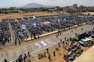
US pauses nightly strikes on Iran as Houthis, Saudis clash
Skirmishes between Houthi rebels and Saudi Arabia intensified as a pause in the nearly two-week run of nightly U.S. strikes on Iran raised fresh questions about President Donald Trump’s strategy in the war.
The Houthis, Islamist militants based in Yemen and backed by Iran, said they fired missiles and drones at facilities linked to oil giant ...Read more
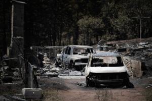
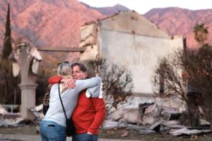
Colorado wildfires: All evacuations lifted for Aspen Acres fire
The last residents evacuated by the massive Aspen Acres fire in southern Colorado were allowed to return home Saturday, but thunderstorms could cause flash flooding in the fire’s burn scar.
As of Saturday morning, all mandatory evacuation zones had been downgraded to pre-evacuation status or cleared, according to an update from fire officials...Read more

Woman, 78, dies, 17 firefighters hospitalized as blaze tears through row of Queens homes: FDNY
A 78-year-old woman died and 22 other others, including more than a dozen firefighters, were injured after a massive blaze ripped through a Queens home Saturday morning, police and FDNY officials said.
Flames erupted about 9:50 a.m. on the first floor of the two-story home on College Point Blvd. near 41st Road in Flushing, before spreading to ...Read more

'It feels like it never ends -- the evil': Pasadena demonstrators protest ICE shootings
LOS ANGELES — Approximately 50 demonstrators gathered Saturday morning in Pasadena as part of a national action to honor lives lost during immigration enforcement operations and in detention centers during the Trump administration.
They wore flyers around their necks, hung with yellow thread, bearing the smiling faces and names of some of ...Read more

Recent UChicago study shows uptick in violence around schools shuttered in 2013
CHICAGO — In 2013, the closures of 49 public schools were referred to by then-Chicago Teachers Union chief Karen Lewis as “a scorched earth policy,” not an education plan.
When the Chicago Board of Education approved the closures that affected the city’s South and West Side neighborhoods, tears were shed, insults were exchanged, and ...Read more
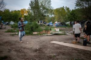
St. Paul wants no more homeless encampments by winter. Many question the plan
ST. PAUL, Minn. — Outside St. Paul’s largest homeless encampment in an out-of-the-way East Side park near the river, a small army of outreach workers, case managers and social workers were set up behind a bank of laptops under white pop-up tents.
The encampment’s residents lined up to plug back into Ramsey County welfare systems and try ...Read more

Brazil blocks visas of US envoys over election interference
Brazil has denied visas to two senior U.S. State Department officials whom the Trump administration planned to send to scrutinize the fairness and integrity of the country’s electoral system before the Oct. 4 presidential vote.
The Brazilian Foreign Ministry confirmed to Bloomberg News that it had denied the visas. The government saw the ...Read more
Popular Stories
- US pauses nightly strikes on Iran as Houthis, Saudis clash
- 'Deportation factory': Chicago's immigration court epicenter for US spike in removal orders, analysis shows
- As North America grapples with destructive wildfires, 'super' El Niño may offer hope
- Mayor Mamdani's vision for NYC school integration is broader than admissions reforms
- Kazakh president urges Putin to freeze Ukraine war
Comics