The first atmospheric river of Super El Niño is coming. Here's when it could hit
Published in News & Features
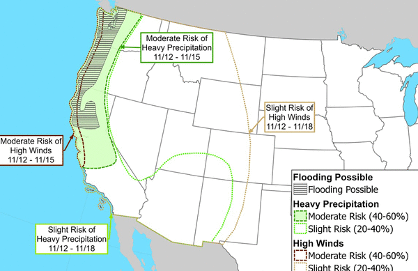
SACRAMENTO, Calif. — The weather is dry for the moment, but signs across the atmosphere are painting a clear picture for when the first atmospheric river will bring rain to California.
As El Niño begins to lock into the atmosphere, it will continue to set up patterns like the one we will see next week, with lower pressure just offshore and a lingering dome of high pressure across the central United States.
Patterns like this that hold in place for a week or more are exceptional at squeezing out oceanic moisture in the form of atmospheric rivers – strings of the jet stream that become saturated with relentless rain. And the first of the season for Central California is taking shape for next week.
Several atmospheric rivers likely in mid-November
The next seven or so days look quite dry. A stable atmosphere overhead will make for a wonderful week of high temperatures in the upper 60s and low 70s across most of the Golden State.
The trouble comes when this stability moves east. With low pressure already spinning away in the Gulf of Alaska, any stable atmosphere that moves east will pull that Gulf of Alaska low south, where it will quickly be saturated with extra moisture from El Niño and form an atmospheric river.
It is too early to say which day these long-lasting rains could ring out over California, but the probable window is approximately Nov. 11-16, with rain likely only lasting for a day or two.
Atmospheric river rains can be substantial, especially with extra fuel to work with thanks to El Niño. Many areas could quickly see a month's worth of rain in just a few days.
Early projections show Sacramento could receive its entire November rain average — nearly two inches — in the short window. Other areas statewide could see similar numbers, with a general trend for more rain falling in Northern California.
It’s not just rainfall. An early look at what this would mean for Sierra snow shows several feet in placesr. Some Tahoe area resorts are already set to open early, and this should put the rest in a good position to join them.
This is a setup that will grow increasingly common into winter. El Niño is still set to strengthen for another month or two. During that time, don’t be surprised if it feels like these rain events begin to occur on a nearly weekly basis by January.
____
©2026 The Sacramento Bee. Visit at sacbee.com. Distributed by Tribune Content Agency, LLC.






Comments