Could a hurricane send floods to Southern California for Labor Day weekend?
Published in News & Features
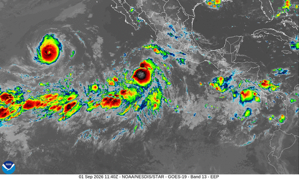
LOS ANGELES -- Could Southern California be at risk of flooding from the remnants of a hurricane this Labor Day weekend?
It’s a possibility, some weather experts say, and scientists Tuesday are closely watching Tropical Storm Marie develop in the eastern Pacific Ocean, south of the Baja California peninsula.
Tropical Storm Marie is forecast to turn into Hurricane Marie by Wednesday, the National Hurricane Center said Tuesday.
There’s high uncertainty over the path the storm will take, the National Weather Service office in San Diego said.
The most likely scenario is that Marie will simply veer to the west, according to the weather service.
But there’s also a decent chance the storm system will head north and make its way over Southern California, bringing with it the risk of flooding, said University of California climate scientist Daniel Swain.
The most realistic worst-case scenario is not an actual hurricane landing in Southern California, Swain said.
Even if the storm system heads to the region, said Sebastian Westerink, meteorologist for the weather service’s San Diego office, “by the time this storm reaches Southern California, it will very likely be below hurricane status and even tropical storm status.”
Swain said a more likely medium-impact scenario would be “a decaying tropical storm that weakens to below-tropical-storm strength before bringing breezy conditions, tons of moisture, and some pretty hefty showers and thunderstorms into Southern California this weekend, along with waves that will be dangerous along the coast.”
Specifically, there’s a risk of coastal flooding, according to the weather service, with swells from the storm forecast to arrive on Saturday and Sunday, just as some of the highest high tides of the month come in.
“There’s increasing confidence in moderate-to-large surf from the south swell starting as early as Friday. We could have coastal flooding because we’ll have above-normal tides during the same time,” especially along south-facing shores, said Kristan Lund, meteorologist with the weather service office in Oxnard.
The winds wouldn’t really be the concern in any scenario; there’s no need to board up windows, Swain said. “There is essentially no scenario where the winds from this event would be stronger than what you get in a strong winter storm.”
The worry would be the rain.
Among the possible scenarios are a tropical storm that makes landfall near L.A. on Labor Day. Should there be heavy rainfall in the mountains, that poses a serious threat of flash floods, landslides and debris flow, according to Swain. Another scenario involves a storm track similar to the one in 2023 that sent a post-tropical low from the remains of Hurricane Hilary over Southern California.
The National Weather Service office in Oxnard said there’s a low chance of widespread moderate-to-heavy rain with flooding.
Although L.A. was spared a direct hit from Hilary, it did cause around $900 million in damage in the U.S. and at least $14 million in damage in Baja California Sur (there were no estimates for Baja California). There were two deaths in Baja California — two people who drowned after their vehicles were swept away by floodwaters — and a woman in California presumed dead after her mobile home was washed away in flooding along the Santa Ana River in San Bernardino County.
Among the areas hard hit in 2023 were the Coachella Valley, San Bernardino County and Death Valley National Park.
In California’s modern record, there have been only two storms that were at tropical-storm strength as they passed through the state: a September 1939 storm nicknamed El Cordonazo or the Lash of St. Francis, which hit Long Beach and San Pedro. It dumped 5.62 inches of rain on L.A. over three days, sent wind gusts of up to 65 mph and resulted in 45 deaths from flooding on land, with an additional 48 deaths at sea.
There was also Nora in September 1997, which was briefly at tropical-storm strength as its center passed along the California-Arizona border, but California was spared the kind of damage it delivered to Baja California. Street flooding was reported in Imperial County, the Coachella Valley and San Diego, while big waves boosted by Nora and another storm sent breakers crashing into beachfront homes in Seal Beach, seriously damaging three homes and resulting in minor damage to 45 others.
Nora arrived during a “very strong” El Niño — a climate pattern involving a warming of the central and eastern tropical Pacific Ocean. That pattern is linked to above-average hurricane activity in the eastern Pacific, and also is usually tied to above-average rainfall for Southern California in the winter.
Forecasters expect the El Niño currently developing in the Pacific will become “very strong” later this year.
The eastern Pacific has been seeing an unusually active hurricane season, which is thought to be linked to the developing El Niño.
Researchers suspect that a hurricane last directly impacted California on Oct. 2, 1858. Originally unknown to meteorologists until about 22 years ago, scientists went through newspaper accounts and other observations and concluded the hurricane was due west of San Diego and lashed the city with hurricane-force winds, while tropical-force storm winds were felt all the way up to the Long Beach area, according to a report in the Bulletin of the American Meteorological Society in 2004.
The storm was so powerful that ships were driven ashore, the report said. “Today, if a Category 1 hurricane made a direct landfall in either San Diego or Los Angeles, damage from such a storm would likely be on the order of a few to several hundred million dollars.”
For a hurricane or a tropical storm to hit Southern California, Westerink said, “you almost need the perfect storm ... of a hurricane that forms somewhere out in the Pacific, is very strong and sort of barrels along the Baja coast as a Category 4 or 5, and manages to keep its momentum until it reaches Southern California without having weakened below hurricane status.
“So that’s very hard, because the waters off Southern California and northern Baja are below 80 degrees, which is almost a critical threshold temperature to sustain hurricanes,” Westerink said.
Temperatures in the ocean around Southern California are higher due to a longstanding and unusual marine heat wave but are generally in the high 60s or low 70s.
“That’s a little bit warm for this time of year, no doubt,” Westerink said, “but still not warm enough to sustain a hurricane or tropical storm.”
Researchers say that more attention needs to be placed on the threat of tropical cyclones — a term that includes hurricanes and tropical storms — to Southern California. A report published in the journal Nature Climate Change in June warned that the kind of punishing rains brought by the storm once known as Hurricane Hilary might not be so exceedingly rare in a world affected by human-caused climate change.
“Our results suggest a broad consensus on the increased (tropical cyclone) rainfall risk under a warmer climate,” said the report, co-written by scientists at Western Michigan University, Stanford University and the Massachusetts Institute of Technology. “Southern California’s population exposure to [tropical cyclone] rainfall-induced landslides will likely increase rapidly from the present to 2050, driven by both the elevated probability of extreme (tropical cyclone) rainfall under a warmer climate and projected population growth.”
©2026 Los Angeles Times. Visit at latimes.com. Distributed by Tribune Content Agency, LLC.






Comments