Hurricane center ups odds again for 1 of 3 Atlantic systems to develop
Published in News & Features
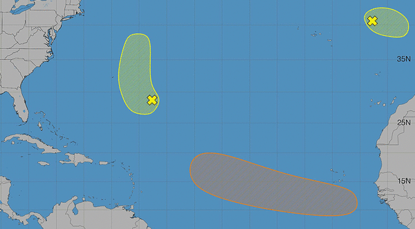
The National Hurricane Center on Sunday increased the odds again that a tropical wave headed for the Atlantic could develop into the season’s next tropical depression or storm. It was one of three systems being watched for development.
As of the NHC’s 8 a.m. advisory, the forecast expects the tropical wave to move into the eastern Atlantic from off the west African coast on Monday.
“An area of low pressure could form in association with the wave early this week,” forecasters said. “Environmental conditions are forecast to be marginally conducive for development, and a tropical depression could form by the middle to latter portions of the week while the system moves generally westward at 15 to 20 mph across the eastern and central tropical Atlantic.”
The NHC gave the system a 50% chance to develop within seven days.
The other two systems being tracked by the NHC are no threat to Florida and have low chances of development.
One located in the northeastern Atlantic is a strong nontropical area of low pressure a few hundred miles west of the coast of Portugal.
“This system has only a slight chance of acquiring subtropical characteristics later today while it moves eastward to east-northeastward at 10 to 15 mph toward Portugal and northwestern Spain,” forecasters said. “By tonight, the low will encounter unfavorable environmental conditions, and further development is not expected.”
The NHC lowered its forecast to just a 10% chance to develop in the next two to seven days.
The final system is a trough of low pressure in the central subtropical Atlantic a few hundred miles southeast of Bermuda with disorganized shower activity.
“Some development of this system is possible during the next few days as it drifts northwestward today and then accelerates northward early this week,” forecasters said.
The NHC gave it a 20% chance to develop in the next two days and 30% in the next seven.
So far the 2026 Atlantic hurricane season, which began June 1 and runs through Nov. 30, has been slow with only three named systems: Tropical storms Arthur, Bertha and Cristobal.
The next names on the list are Dolly and Edouard.
The National Oceanic and Atmospheric Administration earlier this month updated its seasonal forecast and now expects between seven and 13 named storms this year. Of those, two to six would become hurricanes. It also predicted that there might not be any major hurricanes this year, or at most two.
Already, 2026 was forecast to have lower-than-average storm generation, and that has been reduced even further with the latest forecasts from the NOAA and other weather groups.
An average year would see 14 named storms and seven hurricanes, with three of those growing to Category 3 strength or higher.
The height of hurricane season has just begun and runs through mid-October.
_____
©2026 Orlando Sentinel. Visit orlandosentinel.com. Distributed by Tribune Content Agency, LLC.






Comments