Hurricane center eyes 2 Caribbean-bound systems as Cristobal falls apart
Published in News & Features
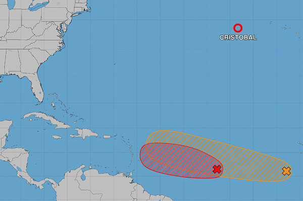
ORLANDO, Fla. — The National Hurricane Center on Thursday kept its eyes on two Caribbean-bound tropical waves that could develop into the season’s next tropical depression or storm while the short-lived Tropical Storm Cristobal fell apart in the distant Atlantic.
As of 11 a.m. EDT, the center of what had diminished to Post-Tropical Cyclone Cristobal less than 24 hours since forming was located 535 miles west-northwest of the Azores with maximum sustained winds of 30 mph heading northeast at 16 mph. That was the last advisory for the degenerated storm.
Still in the developing stages are a pair of tropical waves in the central and eastern tropical Atlantic, both now forecast to form into at least a tropical depression.
As of the NHC’s 8 p.m. tropical outlook, the closer of the two, officially Invest 92, was located about 800 miles east of the Caribbean’s Lesser Antilles, although its showers and thunderstorms continued to become less organized since Thursday morning.
“This system is moving into a region of increasing upper-level winds and dry air, and the possibility of development appears to be decreasing,” forecasters said. “Regardless of development, interests in the Lesser Antilles should continue to monitor the progress of this system since gusty winds and areas of heavy rain are possible across these islands Friday night and Saturday.”
The NHC dropped its forecast to 40% it would develop in the next two to seven days, down from 60% earlier Thursday and 80% Wednesday night.
Right behind it, and now Invest 94, is a tropical wave located several hundred miles southwest of the Cape Verde Islands with disorganized showers and thunderstorms.
“Environmental conditions are forecast to be generally conducive for gradual development, and a tropical depression could form late this week or this weekend while the wave moves westward or west-northwestward across the eastern and central tropical Atlantic,” forecasters said.
The NHC gave it a 30% chance to develop in the next two days and 50% in the next seven.
If either system were to grow into a named system, they could become Tropical Storm Dolly.
The active tropics comes on the 22nd anniversary of Hurricane Charley slamming into Florida, the beginning of one of the worst hurricane years in the state’s history.
So far the 2026 Atlantic hurricane season, which began June 1 and runs through Nov. 30, has been slow with only three named systems – tropical storms Arthur and Bertha and now Cristobal.
After Dolly, the next name on the list is Edouard.
The National Oceanic and Atmospheric Administration earlier this month updated its seasonal forecast stating it expects between seven and 13 named storms this year. Of those, two to six would become hurricanes. It also predicted that there might not be any major hurricanes this year, or at most two.
Already 2026 was forecast to have lower-than-average storm generation, and that has been reduced even further with the latest forecasts from the NOAA and other weather groups.
An average year would see 14 named storms and seven hurricanes, with three of those growing to Category 3 strength or higher.
The height of hurricane season is just beginning, though, running between mid-August and mid-October.
-----------
©2026 Orlando Sentinel. Visit at orlandosentinel.com. Distributed by Tribune Content Agency, LLC.





Comments