Tropical Storm Bertha makes landfall on Gulf Coast, NHC says
Published in News & Features
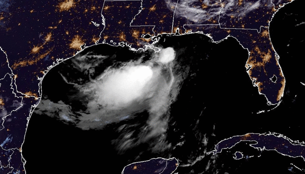
Tropical Storm Bertha weakened Wednesday as it moved west along the Gulf Coast and made landfall in southeastern Louisiana, according to the National Hurricane Center.
The system moved ashore in St. Bernard Parish near the Biloxi Wildlife Management Area, according to a special 3 p.m. EDT update, still with 45 mph sustained winds and higher gusts located about 45 miles southwest of Biloxi, Mississippi, and 40 miles east of New Orleans, moving west-northwest at 7 mph.
As of 2 p.m., the tropical storm warning east of the Alabama/Florida border had been discontinued, but remained in effect from the border west to Morgan City, Louisiana as well as for metropolitan New Orleans and Lake Pontchartrain. A tropical storm watch is in effect from west of Morgan City to Sargent, Texas, plus Lake Maurepas.
“A westward motion with an increase in forward speed is expected to resume later today and continue through Friday,” said NHC Warning Coordination Meteorologist Robbie Berg. “On the forecast track, the center of Bertha will move near or along the Louisiana and upper Texas coasts through Thursday, and then move farther inland into Texas on Friday.”
Tropical-storm-force winds still extend outward up to 105 miles from Bertha’s center, but much of the rain is situated to the south.
The storm had diminished since Tuesday, when it had sustained winds of up to 60 mph.
“Additional weakening is forecast during the next couple of days, but Bertha could maintain tropical storm intensity through late Thursday,” Berg said.
Bertha grew out of what had been the second tropical depression of the Atlantic hurricane season, forming Monday.
For now, tropical storm conditions continue to spread across portions of the northern Gulf.
The biggest storm surge threat is 2-4 feet above normal from the mouth of the Mississippi River to the Mississippi-Alabama border, and 1-3 feet from the Mississippi-Alabama border to the Okaloosa/Walton County line in Florida, from Cameron, Louisiana, to the Mississippi River and Lake Pontchartrain.
Rainfall amounts of 1-4 inches with some areas getting up to 6 inches are forecast through Thursday along the central to western Gulf Coast from western Florida through southern Texas.
Swells along the coast could cause life-threatening surf and rip current conditions.
Short-lived Tropical Storm Arthur was the season’s first named storm that developed in the Gulf and brought floods to Texas and Louisiana in June.
Cristobal is the next name on the hurricane season list, followed by Dolly.
The season officially began June 1 and runs through Nov. 30. The height of hurricane season runs from mid-August into October.
The National Oceanic and Atmospheric Administration expects this season to be below normal, with the official forecast released in late May calling for 8-14 named storms of which 3-6 would become hurricanes. Of those, 1-3 would become major hurricanes reaching Category 3 status or above.
An average season has 14 named storms, seven hurricanes and three major hurricanes.
_____
©2026 Orlando Sentinel. Visit at orlandosentinel.com. Distributed by Tribune Content Agency, LLC.






Comments