Odds up for tropical system to form off Florida coast, hurricane center says
Published in News & Features


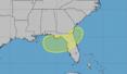

ORLANDO, Fla. — The National Hurricane Center on Friday increased its forecast chances a system forming off the Florida coast could become the season’s next tropical depression or storm.
In its 2 p.m. tropical outlook, the NHC said that a large area of showers and thunderstorms has congregated over the eastern Gulf associated with an upper-level low and a surface trough.
“Some gradual development of this system is possible while it meanders northward, bringing heavy rain to portions of the Florida west coast during the next several days,” forecasters said.
The NHC, which began tracking the system on Wednesday, now gives the system a 10% chance to develop in the next two days and 30% in the next seven.
The National Weather Service in Melbourne said a mid and surface level high pressure will weaken across east Central Florida today, with troughing beginning to develop across western Florida and the eastern Gulf, which would help development of the low pressure area in the Gulf.
“Regardless, the development of the low will lead to a tightening pressure gradient across east Central Florida,with southerly winds picking up to 10 to 15 mph areawide,” forecasters said. “Increasing moisture through the weekend and into early next week as a result of the southerly flow and the developing low will lead to scattered to numerous shower and storm chances across the area, primarily during the afternoon hours each day.”
There is a marginal risk for excessive rainfall on Monday because of saturated soils and the ongoing active rain pattern.
“Shower and storm activity is forecast to diminish into the overnight hours each day, with ongoing isolated to scattered showers and storms possible across the local Atlantic waters each night,” forecasters said.
The NHC also continued tracking a broad area of low pressure associated with a tropical wave in the eastern tropical Atlantic near the southern Cape Verde Islands, which is likely to experience gusty winds and local heavy rain Friday.
“The low continues to produce a limited and disorganized area of showers and thunderstorms while it moves west-northwestward at 10 to 15 mph,” forecasters said. “Significant development of this system is not expected before environmental conditions become even less favorable for development over the weekend.”
The NHC gave it just a 10% chance to develop in the next two to seven days.
The 2026 hurricane season so far has had just one named system, the short-lived Tropical Storm Arthur that developed in the Gulf and brought floods to Texas and Louisiana in June.
The next names on the hurricane season list are Bertha and Cristobal.
The season officially began June 1 and runs through Nov. 30. The height of hurricane season runs from mid-August into October.
The National Oceanic and Atmospheric Administration expects this season to be below normal with the official forecast released in late May calling for 8-14 named storms, of which 3-6 would become hurricanes. Of those, 1-3 would become major hurricanes reaching Category 3 status or above.
An average season has 14 named storms, seven hurricanes and three major hurricanes.
-------------
©2026 Orlando Sentinel. Visit at orlandosentinel.com. Distributed by Tribune Content Agency, LLC.






Comments