Tropical Storm Arthur forms in Gulf, hurricane center says
Published in News & Features
ORLANDO, Fla. — The National Hurricane Center on Wednesday said Tropical Storm Arthur formed off the Texas coast, making it the Atlantic season’s first named storm.
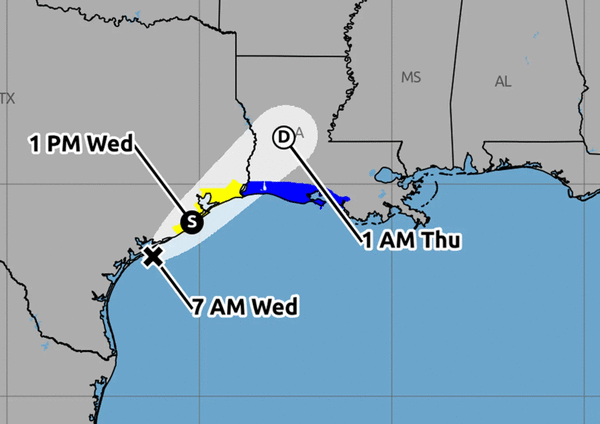
As of a special NHC 11:30 a.m. EDT advisory, the center of Arthur was located about 60 miles east-northeast of Port O’Connor, Texas and 165 miles west-southwest of Lake Charles, Louisiana with maximum sustained winds of 45 mph and moving northeast at 9 mph.
Tropical-storm-force winds extend out 175 miles from its center.
“An increase in forward speed is expected today. On the forecast track, the low pressure area should move northeastward along the Texas coast today and then move inland over southwestern Louisiana by tonight,” forecasters said. ”
A tropical storm warning now is in place from Sargent, Texas east to Morgan City, Louisiana.
“Little change in strength is expected before the center moves over land. Weakening is anticipated once the low moves inland, and it could dissipate by tonight or early Thursday,” forecasters said.
Tropical Storm Arthur tracking map: Updated path and forecast
The system is forecast to drop 5-10 inches of rain, with some areas getting up to 20 inches through Thursday from the mid to upper Texas coast and much of Louisiana as well as portions of Mississippi and Alabama and the western portions of Georgia and the Florida Panhandle.
“This could generate dangerous to life-threatening flash flooding,” forecasters said
Tropical-storm conditions could begin early Wednesday within the watch area, and warning area by later Wednesday, while a storm surge threat of 2-4 feet is forecast from Port Bolivar, Texas, to Morgan City, Louisiana. Swells from the system could cause life-threatening surf and rip current conditions along the northwestern Gulf Coast for the next couple of days.
The system could also produce tornadoes beginning Tuesday night threatening areas from the upper Texas coast across southern Louisiana, Mississippi, Alabama and the the Florida Panhandle, forecasters warn.
This was the first potential tropical system being tracked by the NHC in the Atlantic basin since the start of hurricane season.
The eastern Pacific has already been busy with three tropical storms, but so far the Atlantic basin has been quiet.
Hurricane season officially began June 1 and runs through Nov. 30. The height of hurricane season runs from mid-August into October.
The National Oceanic and Atmospheric Administration expects this season to be below normal, with the official forecast released in late May calling for 8-14 named storms, of which 3-6 would become hurricanes. Of those, 1-3 would become major hurricanes reaching Category 3 status or above.
An average season has 14 named storms, seven hurricanes and three major hurricanes.
_____
©2026 Orlando Sentinel. Visit orlandosentinel.com. Distributed by Tribune Content Agency, LLC.


Comments