Rainstorm and fierce winds strike California. Here's what's in store
Published in News & Features
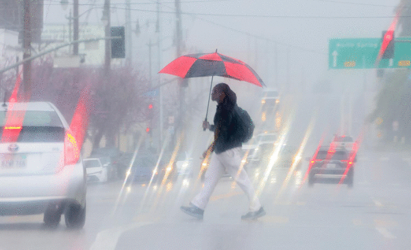
LOS ANGELES — A storm is hitting California late in the wet season, bringing rain to the north and snow to the Sierra Nevada, with Los Angeles expected to receive light rain in time for the Tuesday afternoon commute.
Strong winds could make driving difficult, especially for high-profile vehicles such as big rigs. Fierce gusts of up to 65 mph are possible on the desert slopes of the San Bernardino Mountains. In Death Valley and the San Gorgonio Pass, which connects the Inland Empire to the Coachella Valley, gusts could hit 60 mph, rev up to 50 mph over the San Gabriel Mountains and Antelope Valley and rise to 40 mph elsewhere in the region.
The rainstorm is expected to bring one-tenth to one-third of an inch of rain in Los Angeles and Ventura counties and peak between 11 a.m. and 8 p.m. Tuesday, the National Weather Service office in Oxnard said.
Rain was expected to arrive earlier in Santa Barbara and San Luis Obispo counties, bringing half an inch to an inch of rain, especially between 6 a.m. and 6 p.m. Tuesday.
There's a 20% to 42% chance of rain falling in Orange County, the Inland Empire and coastal San Diego County on Tuesday night into Wednesday morning.
Getting a storm in mid-to-late April might seem unusual for California, but it has happened before. In 2024, a storm arrived in mid-April, according to NWS meteorologist Lisa Phillips, and in a storm in late April 2025, downtown Los Angeles got 0.22 inches of rain.
So far this month, downtown L.A. has recorded 0.38 inches of rain; the average for the first 20 days of the month is 0.55 inches.
"It's definitely coming to the end of our rainy period," Phillips said.
Precipitation was expected to be more extensive farther north. Wide swaths of Northern California and the Central Valley could get anywhere from half an inch to 1½ inches of rain Monday through Wednesday. Two to three inches were possible in some parts of the Sierra foothills.
There was a potential for thunderstorms with small hail.
"When thunder roars or you see a lightning flash: stop all outdoor activities; go inside a sturdy building; seek shelter in a hard-topped vehicle; wait for 30 minutes after the storm to go back outside," the weather service office in Hanford said.
A winter storm watch took effect Tuesday morning and lasts through Wednesday evening for the Sierra Nevada. Up to 2 feet of snow could fall at the highest peaks, and 12 to 18 inches at spots with an elevation of 5,000 feet above sea level, the weather service office in Sacramento said.
"Travel could be very difficult to impossible" across the Sierra, the weather service said. "Travel delays are likely."
This water year thus far has been relatively average in terms of rain. Downtown L.A. has received 18.98 inches of rain since Oct. 1, the start of the water year; the average at this point is 13.53 inches. Downtown San Francisco has received 18.37 inches of rain, short of the average of 21.48 inches at this time of year.
But alarm bells have been ringing over California enduring its second-worst snow drought in 50 years, a sign of how rising temperatures from climate change are worsening the West's long-term water supply problems.
It was the hottest and driest March in the record books for California — even hotter than it is, on average, in May. That heat melted too much snow in California's mountains — the gigantic natural frozen reservoir in the Sierra — flushing out to the sea an alarming amount of water the state would rather keep icy and stored for use later in the summer. California traditionally has relied on the Sierra snowpack to store about 30% of its water.
All that heat and premature melting of the snowpack mean the state's forests will dry out a month earlier than usual, or even sooner, increasing the risk of wildfires, according to Peter Gleick, a leading water scientist and co-founder of the Pacific Institute.
Cities and farms will probably still have ample water because major reservoirs in Northern California are nearly full.
But another major water source for Southern California, the Colorado River, also has been affected by a long-lasting megadrought that began in 2000. The drought is considered the most severe in 1,200 years, intensified by global warming.
The Colorado River is home to the nation's largest and second-largest reservoirs — Lake Mead, near Las Vegas and held up by the Hoover Dam, and Lake Powell, which is on the Arizona-Utah border.
The Trump administration is taking emergency measures to prevent the water level at Lake Powell from getting too low. Lake Powell is 23% full.
Measures include shrinking how much water leaves that reservoir, which flows down the Colorado River into Lake Mead and supplies water to Southern California, Nevada and Arizona.
Lake Mead was last full in 2000, and its water levels have steadily dropped. It was 32% full as of Saturday. Experts say they don't expect lakes Mead and Powell to refill in our lifetimes.
"What we have in our reservoirs in California is all we're going to get," said Karla Nemeth, director of the California Department of Water Resources, earlier this year. "So it means every Californian needs to use water as carefully as they can."
----------
—Times staff writers Sean Greene, Ian James and Terry Castleman contributed to this report.
©2026 Los Angeles Times. Visit at latimes.com. Distributed by Tribune Content Agency, LLC.


Comments