Current News
/ArcaMax

Column: Political giants and moral degenerates: My five best books of 2025
The blame for America’s current troubles lies squarely with the Democratic establishment. Donald Trump’s re-election was always unlikely given his low approval ratings and divisive style. The Democratic establishment turned it into a certainty by: (1) running an aged and obviously ailing candidate (2) using its power over the press, almost a...Read more

Flu season could get a lot worse in the coming weeks, experts say
NORFOLK, Va. — This flu season has been relatively mild so far but medical experts expect it to intensify in the coming weeks due to a new strain that emerged after the current vaccine’s production — though that inoculation remains the best form of protection.
Data out of the United Kingdom indicates the new strain has resulted in the ...Read more

Florida set a record for executions in 2025. What to know
TAMPA, Fla. — When the history of Florida’s modern era of capital punishment is written, 2025 will be marked as a year that saw an unprecedented embrace of the death penalty.
The state executed 19 prisoners this year — the most since the death penalty was reinstated in the 1970s.
Executions have been carried out in cases of defendants ...Read more

New Maryland laws coming into effect New Year's Day 2026
BALTIMORE — As the state prepares for its annual General Assembly session beginning Jan. 14, 2026, there are still new laws from last session set to take effect on New Year’s Day.
Below is a sample of some of the changes coming to Maryland law on Jan. 1, 2026.
No time limits on anesthesia coverage
House Bill 1086 states that if medical ...Read more

One big beautiful bill act complicates state health care affordability efforts
As Congress debates whether to extend the temporary federal subsidies that have helped millions of Americans buy health coverage, a crucial underlying reality is sometimes overlooked: Those subsidies are merely a band-aid covering the often unaffordable cost of health care.
California, Massachusetts, Connecticut, and five other states have set ...Read more

Cozying up to MAGA pays dividends for Germany's far-right AfD
A yearlong campaign by the far-right Alternative for Germany party to court Donald Trump’s MAGA movement is beginning to bear fruit.
Though the country’s largest opposition group is a virtual pariah among the German political elite due to its xenophobic bent, it is gaining traction among ideological allies who hold power in Washington.
...Read more
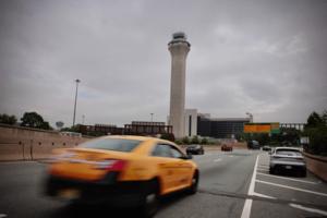
States crack down on aggressive driving
NEW YORK — On a frigid December morning along busy Broadway in the Astoria neighborhood of Queens, New York, pedestrians walk rapidly toward the subway. Cars and e-bikes speed along a busy two-lane road and blast through sharp turns during the early rush to get to the office.
In recent years on this stretch of Broadway, cars have struck and ...Read more
75-year-old CT man ordered to pay back $1.2 million to over 30 state treasuries
A 75-year-old Greenwich man has been ordered to pay back $1.2 million in restitution to 30 state treasuries after being sentenced to three years in prison, officials said.
Henry J. White, Jr., 75, was sentenced Friday by U.S. District Judge Karoline Mehalchick in Pennsylvania to just over three years in prison for submitting false and ...Read more

Boston Police Blotter: POST Commission suspends Karen Read investigator Michael Proctor's certification
It’s really the end for disgraced former Massachusetts State Police Trooper Michael Proctor, who served as the case officer for both the Karen Read and Brian Walshe murder investigations.
The Massachusetts Peace Officer Standards and Training (POST) Commission formally suspended Proctor’s law enforcement certification, according to a ...Read more

US says it intercepted second tanker in Venezuela blockade
The U.S. Coast Guard stopped and boarded an oil tanker in the Caribbean early Saturday that was last docked in Venezuela, Homeland Security Secretary Kristi Noem said, after President Donald Trump ordered a blockade.
The Centuries supertanker laden with up to 2 million barrels of Venezuelan crude was flying a Panamanian flag, according to ...Read more

Chevron steers risky path to oil's biggest prize in Venezuela
For almost two decades, oil giant Chevron Corp.’s stubborn persistence in Venezuela looked like folly: with billion-dollar investments constantly under threat from the tug-of-war between Caracas and Washington, D.C.
Now, however, that strategy has placed the world’s biggest petroleum prize within Chevron’s reach.
As tensions mount ...Read more

Judge keeps alive subpoenas of Fulton County's 2020 ballots
A judge has cleared the way for the Georgia State Election Board to obtain Fulton County ballots and other documents from the 2020 election.
Fulton County Superior Court Judge Robert McBurney on Friday ruled that the election board is well within its authority to request the information it has sought for more than a year. He ordered the county ...Read more

Massachusetts Democrats ramp up anti-ICE rhetoric as deportations continue
Massachusetts political leaders are ramping up messaging against federal agents with Immigration and Customs Enforcement (ICE) as the Trump Administration’s crackdown on illegal immigration continues.
The federal agency is under attack from Bay State Democrats, including the likes of U.S. Senate candidate and Congressman Seth Moulton (MA-06),...Read more

New Maryland laws taking effect New Year's Day 2026
As the state prepares for its annual General Assembly session beginning Jan. 14, 2026, several laws passed last session are set to take effect Jan. 1.
Below is a sample of changes coming to Maryland law on New Year’s Day.
No time limits on anesthesia coverage
House Bill 1086 states that if medical insurers in Maryland, including the ...Read more

Chaotic night on LA roads: Ambulance chase, Porsche crash, 210 ejection death
LOS ANGELES — At least two people were killed and two police officers injured in a series of traffic incidents across Los Angeles late Friday and early Saturday morning.
The events — which occurred on a night of foggy weather — included police chasing a suspected ambulance thief, a collision between a Porsche and an LAPD patrol car and a ...Read more

Pontiac residents march in solidarity with immigrant community
Pontiac is not Detroit, City Councilman Mikal Goodman noted. It's not Los Angeles or Chicago. But it is a place, he said, where national immigration politics are hitting home.
The city has seen rapidly increasing deportations, Goodman said at an immigrant rights rally in his city on Saturday.
"It's very easy for everyone to feel these things ...Read more

ICE detainee dies day after arriving at Newark's troubled Delaney Hall
Jean Wilson Brutus, a 41-year-old Haitian national in ICE custody, suffered a medical emergency and died just one day after he arrived at Delaney Hall in Newark, according to federal officials.
Brutus is believed to be the first detainee to die at Delaney Hall since the troubled, privately run detention center opened in May. It’s since been ...Read more

Social media users in the Central Valley are freaking out about unusual fog, and what might be in it
LOS ANGELES — A 400-mile blanket of fog has socked in California’s Central Valley for weeks. Scientists and meteorologists say the conditions for such persistent cloud cover are ripe: an early wet season, cold temperatures and a stable, unmoving high pressure system.
But take a stroll through X, Instagram or TikTok, and you’ll see not ...Read more

Jury acquits L.A. man who towed immigration agent's car during TikTok influencer's arrest
LOS ANGELES — A federal jury has acquitted a South L.A. man who was charged with stealing government property by towing an immigration agent’s vehicle during the arrest of a TikTok influencer in downtown Los Angeles earlier this year.
Bobby Nunez was arrested Sept. 2 after he was accused of interfering with the detainment of Tatiana Mafla-...Read more

Out-of-control Bronx bus had history of brake problems, was cleared 7 hours before crash
NEW YORK — The Bx6 bus that barreled through the Bronx, terrorizing passengers as it slammed into multiple cars along a five-block stretch of Longwood Monday, had a history of brake problems, a Daily News investigation has found.
Maintenance records obtained by the Daily News show the bus had just been cleared for service just seven hours ...Read more
Popular Stories
- 'Betrayed': Investors grapple with Trump commuting sentence of man who defrauded them
- On a $1 houseboat, one of the Palisades fire's 'great underdogs' fights to stay afloat
- 'Both sides botched it.' Bass, in unguarded moment, rips responses to Palisades, Eaton fires
- Edison neglected maintenance of its aging transmission lines before the Jan. 7 fires. Now it's trying to catch up
- For LA's mayor, a Palisades recovery marked by missteps, reversals and delays
Comics