Dangerous thunderstorms threaten KC area as severe weather possible over most of Missouri
Published in Weather News
Dangerous storms that are likely to fire up across the middle part of the United States could bring strong to severe storms to the Kansas City area Monday afternoon, according to the National Weather Service in Kansas City.
Warm, muggy air is expected to expand into Kansas City and continue north to the U.S. 36 highway in central Missouri, the weather service said in its forecast discussion.
Scattered thunderstorms are expected to develop Monday afternoon, and severe weather is possible. The main threats include damaging winds, large hail, and isolated tornadoes.
Rainfall totals of one to two inches are possible. Minor, localized flooding will be possible where thunderstorms repeatedly move over the same area. Areas to the east of the U.S. 65 highway are at the greatest threat for minor flooding, according to the weather service.
Before the storms arrive, Kansas City’s temperatures will soar to nearly 80 degrees, well above 61 degrees for this time of year.
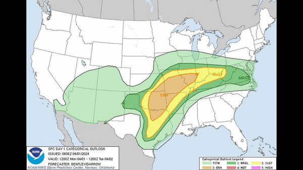
Severe thunderstorms expected across middle US
According to the Weather Service’s Storm Prediction Center, Kansas City’s risk of thunderstorms is part of the severe weather threat likely to occur across a broad region, stretching from the southern Plains across the Ozarks and Ohio Valley and into a small part of the Mid-Atlantic coast.
Large to very large hail, damaging winds, and tornadoes, some of which might be strong, are possible.
The Storm Prediction Center has placed Kansas City under a slight risk of severe thunderstorms, the second category of its five severe thunderstorm risk categories.
Meanwhile, southwest, central and eastern Missouri, along with parts of Texas, Oklahoma and Illinois are at an enhanced risk of severe weather.
Multiple rounds of supercells — large thunderstorms with deep and persistent rotating updrafts that look like tall storm clouds with anvils or elongated clouds at the top — will be possible in some areas where the strongest storms develop.
Cooler and breezy conditions are expected to move in after the storms exit the Kansas City area.
Temperatures will be in the low to mid-50s for most of the week, five to 10 degrees below normal. They will then drop to near freezing each night through Friday.
Temperatures will begin warming for the weekend on Friday, reaching the upper 60s. For Saturday and Sunday, expect low- to mid-70-degree weather.
©2024 The Kansas City Star. Visit at kansascity.com. Distributed by Tribune Content Agency, LLC.


Comments