Washington's third-worst fire season in past 20 years burns 1,125 square miles
Published in News & Features
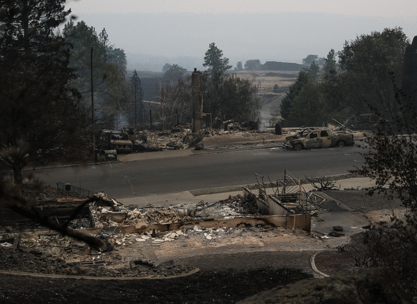
SEATTLE — Three wildfires across the state are burning more than 100,000 acres each, as Washington experiences the third worst fire season it has had in the past 20 years.
More than 720,000 acres, or 1,125 square miles, have burned this year so far, according to the Northwest Interagency Coordination Center, putting it behind record years in 2015 and 2020, said the state’s Department of Natural Resources spokesperson Thomas Kyle-Milward.
The figure represents nearly 2% of the state’s total land area. There are still about two months left for the state’s fire season.
On Monday, more than 555,000 acres, or nearly 900 square miles, were on fire across the state among dozens of large wildfires, the Northwest Interagency Coordination Center said.
But despite the sheer acreage burning, fireside communities are seeing evacuation orders reduced. A strong system midweek could bring gustier winds and thunderstorms but also showers, cooler temperatures and higher humidity in Northern Washington, which has seen heavy fire activity, fire officials said.
Evacuation orders have been downgraded to Level 1, “Get ready to leave,” around the trio of wildfires in Spokane, after the Old Trails, Autumn Lane and Fairview fires tore through more than 900 structures and caused more than 60,000 people to evacuate.
Areas in and around the fire’s path of devastation are still under Level 3 evacuation orders, the Spokane County sheriff’s office said. For those returning home, the city warned residents to wear personal protective equipment and offered guidelines on what to do once they reenter their homes.
The Autumn Lanes fire, the biggest of the three, was the most under control on Monday with 73% containment at 5,776 acres or 9 square miles, according to the Northwest Interagency Coordination Center. The Old Trails and Fairview fires were both 53% contained at 3,176 and 992 acres respectively.
South of Spokane in Malden in Whitman County, where the Wells Road fire sparked up over the weekend, immediate evacuation orders were downgraded to level 2 “Be ready” to leave, and level 2 orders in Rosalia were downgraded to level 1, according to the fire management team.
The Wells Road fire was 0% contained at about 2,000 acres Sunday evening, the management team said. Fire crews were aiding the fire in natural progression as it consumed interior islands and old burn scar areas, six years after the Babb Road fire destroyed 80% of the homes in Malden in 2020.
Northwest of Spokane, evacuation orders were also reduced around the Sinlahekin fire which was 42% contained at 141,411 acres, or about 220 square miles, on Monday morning. Residents are still asked to be ready to evacuate if conditions change.
Further northwest, near the Canadian border and 20 miles outside of Mazama in Okanogan County, the Ptarmigan fire grew moderately to 23,467 acres or about 36 square miles by Monday morning and was 8% contained, according to the fire management team. The blaze was stared by lightning.
Though no one has been evacuated because of the fire, parts of the Okanogan‑Wenatchee National Forest are closed including Harts Pass Road at Monument Creek Trailhead and the Pacific Crest Trail from the West Fork Methow Trail to the Canadian border, the management team said. The public is asked to avoid Forest Service Road 5200.
Also near the Canadian border, a couple dozen miles west near Ross Lake, the Border 2 fire was burning 10,582 acres or 16 square miles on Monday, according to the North Cascades National Park Service Complex, growing thousands of acres since Friday.
Several hiking trails and campgrounds were closed in response.
Heading south, 30 miles northwest of Leavenworth, the Little Giant fire reached 111,429 acres, or about 170 square miles, on Monday and was 2% contained after burning for nearly a month and causing 255 people to evacuate.
The Three Queens fire, 6 miles east of Snoqualmie Pass, was also 0% contained on Monday and has grown to about 2,000 acres since it started nearly a month ago.
Level 3 evacuation orders were expanded Sunday to include cabins and camp areas around Cooper Lake and Cooper River Road while surrounding areas were under level 2 and level 1 orders, according to the fire management team.
Public lands, roads, trails and campgrounds on the west side of the Cle Elum River and Highway 903 were also closed Sunday, the team said, along with several hiking trails in the area.
Further south, near Mount Rainier, the Grand Park 2 fire was 0% contained at 312 acres after it ignited on Friday. The White River Campground and Sunrise area were closed in response along with a stretch of White River Road and Sunrise Road, and all trails connected to those roads and in the Grand Park area, the National Park Service said.
_____
©2026 The Seattle Times. Visit seattletimes.com. Distributed by Tribune Content Agency, LLC.






Comments