Weekend nor'easter leaves flooding, wind damage in Boston area
Published in Weather News
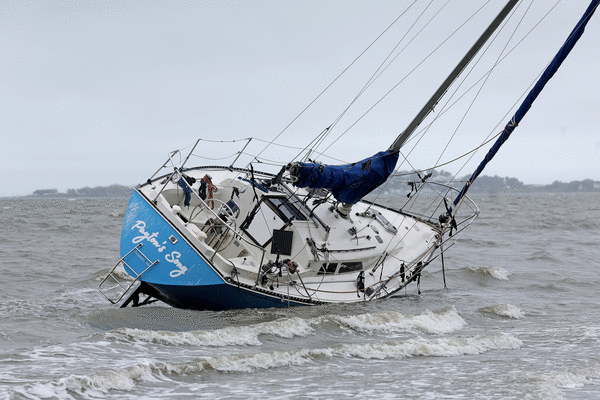
BOSTON — Nor’easter conditions tapered out around the region Monday, leaving flooding and storm damage across the area ahead of drier weather on Tuesday.
“We’ve got a few lingering showers,” said NWS meteorologist Francis Tarasiewicz. “Very isolated areas can see upwards of additional inch or so rain, but the storm is weakening, and it’s going to really start to pull away (Tuesday) afternoon. We may still see a few scattered showers, but really the bulk of the activity is going to be pulling out by Tuesday afternoon.”
Around the greater Boston area, the weekend storm resulted in anywhere from two to six inches of rain from Friday through Monday, according the National Weather Service data.
Logan Airport and Fenway Park recorded just over 2.8 inches of rainfall as of Monday morning, while areas south of the city saw as much as six or seven inches, with Blue Hills recording 8.7 inches.
“We have the Taunton River that’s in flood stage,” said Tarasiewicz. “It’s at about eight and a half feet, which will result in some minor flooding around that river. And then just anecdotally at the office, we received over 170 wind-related damage reports. Many of those being, trees down on homes, trees down on wires, things like that.”
Power outages in Massachusetts remained just under 500 customers as of Monday evening, according to Massachusetts Emergency Management Agency data, down from over mid-storm peak over 10,000.
The area should be “basically done with all the high winds,” Tarasiewicz said Monday. Across New England, gusts reached up to 70 mph in Wellfleet and 71 mph in Block Island, Rhode Island.
Along the storm’s path from the mid-Atlantic up the coast into New England, AccuWeather estimated damages totaled around $10 to $13 billion as of Monday. The forecasters compared the impacts to Hurricane Sandy in 2012, “due to similar tracks and devastating coastal flooding impacts.”
Especially in New Jersey, AccuWeather chief meteorologist Jonathan Porter said, the nor’easter resulted in the highest water levels since Hurricane Sandy and “among the top 5 highest water levels in the observational record in some places.”
Among the economic toll, AccuWeather noted the 200,000 customers without power across Long Island, New Jersey and southeastern New England and the over 500 flight cancelations out of Logan International Airport.
Heading into Tuesday in Boston, conditions are expected to be foggy in the morning, before skies turn partly sunny and temperatures reach a high the upper 60s, NWS forecasts.
Temperatures are forecasted to increase into the 70s starting Wednesday and Thursday, as skies remain partly to mostly sunny.
“By Friday, we could see temps in the upper 70s and maybe near 80 or so around the region with dry conditions,” Tarasiewicz said. “And then a cold front comes through Friday night into Saturday, and that’s going to result in much cooler temperatures on Saturday, probably in the 60s. And the next big rainmaker may arrive by Sunday.”
________
©2026 MediaNews Group, Inc. Visit at bostonherald.com. Distributed by Tribune Content Agency, LLC.






Comments