Aided by El Niño, Hurricane Polo explodes to Category 5 as it nears Baja California
Published in Weather News
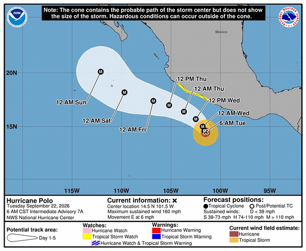
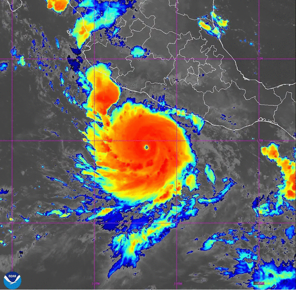
In one of the most dramatic bouts of rapid intensification of a hurricane in the eastern Pacific Ocean on record, Hurricane Polo has exploded into a major Category 5 storm, with more strengthening expected through the day.
As of late Tuesday morning, Polo had maximum winds of 180 mph and was located off the coast of southern Mexico. For reference, Polo’s maximum winds were only 50 mph about 24 hours before.
Polo can also claim another impressive distinction. A mission by the U.S. Air Force Reserve reconnaissance squadron known as the “Hurricane Hunters” on Tuesday just before noon recorded a central surface atmospheric pressure of approximately 892 mb. That puts it in a rare class of hurricanes — only the most powerful storms on Earth attain central pressures below 900 mb.
By this metric, Hurricane Polo is the second-strongest hurricane on record in the eastern Pacific Ocean — only after Hurricane Patricia of 2015, itself the strongest ever recorded by wind speed and a product of that year’s Super El Niño.
Further strengthening is expected in the short term. Polo maintains a robust inner eye wall according to recent radar scans from the Hurricane Hunters, and the National Hurricane Center forecasts winds nearing 180 mph Tuesday night.
El Niño ‘Kelvin waves’ have helped fuel Hurricane Polo
As El Niño continues to push past record territory this week, it continues to drive coastally trapped “Kelvin waves” up the coast of Mexico toward California. These plumes of warm water pack temperatures 5 to 10 degrees Fahrenheit above average, providing extra energy for Hurricane Polo to take advantage of as it strengthens. This extra heat is at least partially responsible for Polo’s incredible rapid intensification since Monday.
Not only is this extra heat in the area Polo intensified, but it is also still traveling north, vastly increasing the area of the ocean where Polo will be able to maintain major hurricane intensity. Normally, water temperatures on the western flank of Baja California do not support hurricanes. That is not the case this time, with nearly the entire coast of Baja California Sur surrounded by temperatures above 80 degrees.
This extra oceanic warmth is also likely to extend hurricane further into fall, with more intense hurricanes more likely than not through at least early November. That could be a big problem for Mexico and the southwestern United States, as the normal dipping troughs of October and November will be more likely to turn these storms northward towards land. So far this season, practically every storm has moved east out to sea.
Hurricane Polo to approach Baja California this weekend
That brings all eyes to Polo, whose expected track over the week will be a steady pace moving northwest along the Mexican coast — thankfully just far enough offshore that impacts will be rather minimal this work week.
That could change by this weekend, when Polo will draw closer to Baja California — likely still as a major hurricane, but probably not as a monster Category 5. From here, there is a chance Polo could get caught in the steering currents and race directly north towards the Baja California coast this weekend or early next week.
If this does come to fruition — a possibility that is not currently forecast — then parts of the southwestern U.S. including Arizona and potentially inland Southern California would need to brace for weakening tropical storm conditions and heavy rains early next week.
The Hurricane Hunters will fly several Hurricane Polo missions over the coming days, gathering critical data to help improve the forecast of this suddenly major storm.
_____
©2026 The Sacramento Bee. Visit sacbee.com. Distributed by Tribune Content Agency, LLC.






Comments