Officials confirm 6 Kentucky tornadoes, straight-line wind damage from severe storm
Published in Weather News
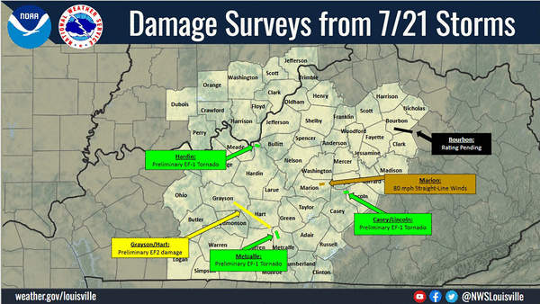
LEXINGTON, Ky. — Storm damage from six tornadoes and straight-line winds was found in several Kentucky communities during National Weather Service surveys on Wednesday.
NWS surveyors confirmed the tornadoes were on the ground in Bourbon, Carroll, Casey, Gallatin, Grant, Grayson, Hardin, Hart, Lincoln, Metcalfe and Owen counties during a severe storm that took place on Tuesday, July 21. Surveyors also found damage from straight-line winds in Bourbon, Clark, Marion, Montgomery and Pulaski counties.
The storm passed through the region Tuesday afternoon, prompting several tornado warnings and leaving thousands without power. The NWS said a combination of supercell thunderstorms and bowing line segments produced damaging winds, isolated large hail, and a few tornadoes
As of 6:30 a.m. Thursday, power across the state was almost fully restored. There were 69 outages reported in Hart County and 51 outages reported in Metcalfe County, according to poweroutage.us.
The storm largely avoided Lexington, although the southern part of Fayette County was under two severe thunderstorm warnings between 4 and 5 p.m., according to the Mesonet. Lexington’s southern Mesonet station recorded a 37.3 mile per hour wind gust at 5:05 p.m. and picked up 0.64 inches of rain.
Anyone who experienced damage from the storms is encouraged to report it to the NWS.
Bourbon County tornado
NWS surveyors reviewed a video that was taken on a property on Oldson Road in southeast Bourbon County. The video showed airborne debris in a small circulation moving across a field, confirming a tornado touched down in the area, according to the NWS.
Officials estimate the EF-0 tornado reached a maximum wind speed of 75 mph and had a maximum width of 25 yards. The NWS said surveyors couldn’t inspect the damage on the ground but believes the tornado traveled about a quarter-mile.
Northern Kentucky tornado
Preliminary information suggests an EF-1 tornado was on the ground in Carroll, Gallatin, Grant and Owen, and counties for 21.7 miles, according to the NWS. The tornado had an estimated maximum wind speed of 110 mph and had an estimated maximum width of 500 yards.
The tornado touched down around 3:12 p.m. along Kentucky Highway 47 near and Interstate 71 in Carroll County. The NWS said significant damage was found between the Gallatin County Airport and Eagle Creek, as a majority of the trees in the area were snapped.
The tornado moved into Owen County and damaged a property with multiple outbuildings on Kentucky Highway 35 near U.S. Highway 127. One person was injured at a home on Stewart Ridge Road when a large RV was rolled by the tornado, according to the NWS.
More damage was found on Golden Circle Road and Jonesville Road, where there were multiple downed trees and several outbuildings with damaged roofs, according to the NWS.
The tornado weakened as it approached Grant County. The NWS said the last evidence of damage was found at a property near Keefer Road, where three outbuildings were virtually destroyed and a house lost a significant portion of its roof.
The tornado lifted around 3:51 p.m. in Grant County, according to the NWS. Owen County Judge-Executive Todd Woodyard declared a local state of emergency as a result of the tornado damage.
Casey-Lincoln tornado
The tornado in Casey and Lincoln counties had an estimated maximum wind speed of 100 mph, according to the NWS. No injuries were reported in connection with the tornado.
The EF-1 tornado touched down in Casey County around 5:37 p.m. along Kentucky Highway 78 near the intersection with Kentucky Highway 906. The NWS said it damaged a barn and snapped several large trees along the highway.
The tornado weakened as it crossed into Lincoln County toward Black Pike west of Hustonville, according to the NWS. Still, the tornado snapped multiple power poles and trees in its path before lifting around 5:39 p.m.
The NWS said the tornado was on the ground for roughly two minutes and traveled 1.2 miles.
The Lincoln County Fire Department shared a few photos of downed trees through the community.
Grayson-Hart tornado
NWS surveyors found damage suggesting the tornado in Grayson and Hart counties reached wind speeds of at least 111 mph. Officials are continuing to investigate the damage to determine the severity of the tornado, according to the NWS.
Hart County Fiscal Court said the storm damaged the county’s animal shelter, but no animals were injured.
Hardin County tornado
The tornado in Hardin County left behind damage along Railroad Trestle Road near Muldraugh and Fort Knox. The NWS said it had an estimated maximum wind speed of 95 mph and a maximum width of 25 yards.
The tornado touched down around 4:03 p.m. and traveled approximately a quarter-mile, according to the NWS. No injuries were reported.
Metcalfe County tornado
NWS surveyors believe the storm damage in Metcalfe County was caused by an EF-1 tornado. No other information about the tornado was available.
Straight-line wind damage
NWS surveyors inspected damage in Bourbon, Clark and Montgomery counties after picture and video evidence showed two funnel clouds in the area. The surveyors visited the locations where the funnel clouds were spotted but found no tornadic damage, according to the NWS.
Officials found three downed trees on Gay Road in Bourbon County, but no other damage was found, according to the NWS.
“None of the damaged trees showed any indication of a tornadic signature, nor were any of the neighboring trees affected,” the NWS office in Jackson said in a social media post. “Unfortunately, there wasn’t enough evidence during this survey to verify that a tornado actually touched down in these three counties.”
In Pulaski County, areas near Slate Branch Road and Oak Hill Road were damaged by the storm, but surveyors did not find any tornadic damage. The NWS said wind speeds were estimated to be between 70 and 80 mph.
“Upon further review of radar data after the survey, it appears that as the storm was quickly strengthening, a strong surge of winds occurred on the west side of the storm,” the NWS Jackson office said in a social media post.
The straight-line wind damage in Marion County was a result of 80 mph winds, according to the NWS.
©2026 Lexington Herald-Leader. Visit at kentucky.com. Distributed by Tribune Content Agency, LLC.






Comments