Major US city skylines in photos, then and now
Published in Slideshow World
Subscribe
Major US city skylines in photos, then and now
Today, certain city structures across America have become synonymous with the skylines they dot, from Seattle's Space Needle to Chicago's Willis Tower and New York City's Empire State Building. While they may now be indelible markers in their metros, these buildings are relatively new. After all, it wasn't until the late 19th century that cities in the United States started to grow at a dramatic rate.
Increasing industrialization in the 19th century spurred that growth, with the development of electric power and steam engines resulting in factories no longer needing to be located near rivers. Instead, they could be in urban areas, drawing even more people into those cities with the promise of steady, though often difficult, jobs.
By the turn of the 20th century, many American cities had distinct identities based on their particular industry. New York served as the national hub for finance, Chicago was a major meat processing base, Los Angeles became a center for film production, and so on. These distinctions only grew as urbanization continued, with the different industries marking the physical landscapes of their cities in specific ways.
Of course, U.S. cities today look radically different than they did a century ago—but what do these differences reveal? How did these changes develop, and how did they affect various cities? Did certain cities expand organically over time, or did they multiply due to technological advancements like Edison's electric lightbulb? To answer some of those questions, Stacker parsed through photo archives and consulted the Council on Tall Buildings and Urban Habitat to find out what 15 major U.S. city skylines looked like about a century ago compared to how they stand today.
Visit thestacker.com for similar lists and stories.
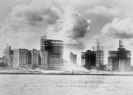
Miami: Then
Taken from Biscayne Bay, this 1925 photograph shows several skyscrapers under construction on land that had been filled in to create more waterfront real estate, including the new Bayfront Park. Most buildings pictured are hotels, built at the peak of Florida's 1920s land boom when the city tripled in population.
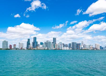
Miami: Now
Over the past century, the skyscrapers along Miami's shore have multiplied, creating a sleek, contemporary city center of gleaming glass high-rises right to the water's edge. But it's not just the city that expanded in a century—the Atlantic Ocean has risen a foot in that same time thanks to climate change, causing frequent floods in Miami and South Florida. If the ocean stays on the same trajectory, more than 800,000 county residents will need to relocate by 2100.
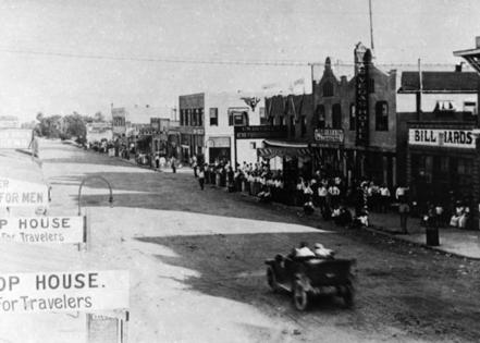
Las Vegas: Then
This 1928 view of Fremont Street depicts a car racing down a dusty dirt road—from the looks of the main drag, it appears this could be any old western frontier town. Few could guess this mining town was about to become the fabulous Las Vegas thanks to two developments on the horizon: the construction of the Hoover Dam and the legalization of gambling in the 1930s.
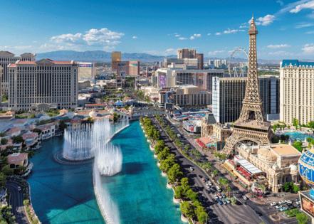
Las Vegas: Now
Fremont Street hosted Vegas' first casinos in the 1940s, but the limelight was quickly stolen by a once-barren stretch of land outside city limits: The Strip, seen in this 2017 photo. The Strip became the development site for glitzier and more fantastical hotel casinos, a few of which had ties to organized crime. Vegas has maintained its reputation as Sin City for decades, though it now boasts an array of family-friendly entertainment options.
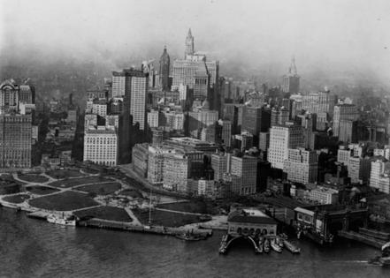
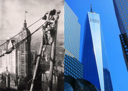
New York City: Then
This 1923 view of Battery Park and lower Manhattan shows a concentration of early skyscrapers that predate the construction of two of the city's most famous landmarks: the Empire State and Chrysler buildings, built in the early 1930s. The tallest building pictured here is the 792-foot Woolworth Building; completed in 1913 and described as "the cathedral of commerce," it was the tallest building in the world until 1930. Skyscrapers provided much-needed office space for New York's financial and commercial businesses.
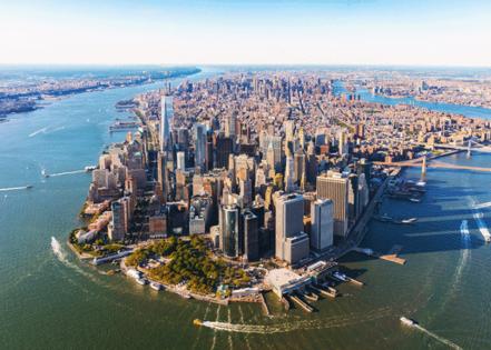
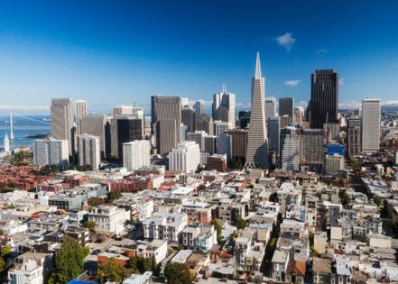
New York City: Now
After the impressive rise of skyscrapers in the 1930s—the Empire State, Chrysler, and 40 Wall Street buildings all went up during this decade—the New York City skyline stagnated, staying almost the same until the World Trade Center was built in 1972. Though the center's iconic twin towers were destroyed in the September 2001 attacks, One World Trade Center set a new record for height when it opened on the site of the towers in 2014. Currently the tallest building in the U.S. at 1,776 feet, One World Trade Center has forever changed the profile of New York City's skyline, as seen in this 2017 photo.
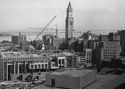
Boston: Then
Boston's Custom House Tower, which looms over the rest of the city in this image, was already 10 years old when this photo was taken in 1925. Added to the existing Custom House building in 1915, the tower remained the city's tallest building until 1964. With cranes and construction surrounding the tower, this image captures Boston as its industrial economy expanded during a massive immigration surge, which saw the city's population more than double between 1880 and 1920.
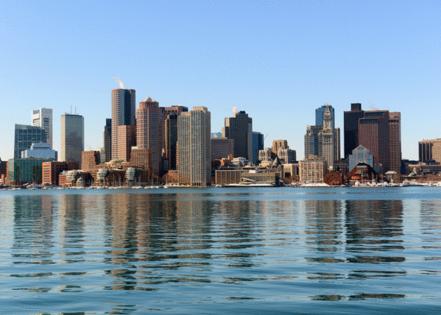
Boston: Now
Custom House Tower remains visible in the city's contemporary skyline, but it's a little like finding a needle in a haystack—it is now the 17th tallest structure in Boston. Like so many other cities, Boston experienced significant migration in the 1920s and '30s, only to see much of its middle-class and affluent population move to the suburbs in the post-World War II period. After decades of downturn, the urban core is once again reinvigorated today, with demands for residential real estate leading to the transformations of old skyscrapers and the construction of new, taller, sleeker ones.
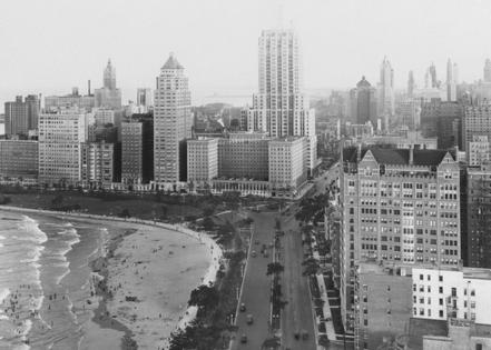
Chicago: Then
Chicago is often described as the birthplace of the modern skyscraper, and this 1929 photo proves it worthy of the title. Here, the newly completed art deco Palmolive building rises above Michigan Avenue—the soap company dubbed its 37-story headquarters "a monument to cleanliness." Little did Palmolive know, it would one day host the headquarters of Playboy magazine.
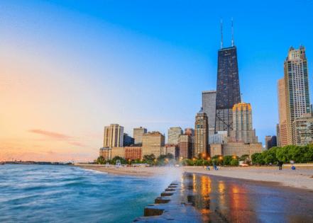
Chicago: Now
Skyscrapers continued cropping up in Chicago throughout the 20th century, including some of the city's great wonders, like the Willis Tower and 875 North Michigan. Michigan Avenue, part of which was designed to be a grand boulevard like Paris' Champs-Élysées, has certainly earned the moniker "The Magnificent Mile." The Wrigley Building, Tribune Tower, the Chicago Water Tower, and many more skyscrapers are located within a mile of each other on this iconic street.
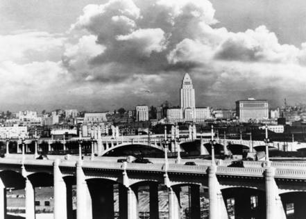
Los Angeles: Then
As depicted in this photograph from 1930, City Hall once loomed over Los Angeles as its tallest building for 36 years. The relatively low-rise design of Los Angeles is no accident—city planners enacted an ordinance capping buildings at 150 feet in height from 1904 to 1959. The art deco-style City Hall building was the only exception.
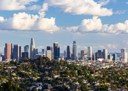
Los Angeles: Now
LA's sprawl now contains plenty of skyscrapers, which can be seen in this 2023 photo of downtown. While earthquakes have always been a concern for the City of Angels, a public vote passed a referendum to end the long-held height restrictions in 1956, and a spate of skyscrapers in the former Bunker Hill neighborhood followed. Towers replaced old Victorian homes, and the city has taken on an entirely new vertical profile thanks to waves of development over the last 68 years.
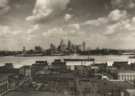
Detroit: Then
A 1929 photograph of the Detroit skyline across the Detroit River shows many art deco marvels, including the 47-story Penobscot Building, which had just been completed in the growing downtown financial district. In the decades before the Great Depression, the city grew rapidly due to the automobile industry. The skyline reflects that success, with many of its skyscrapers dating back to that time.
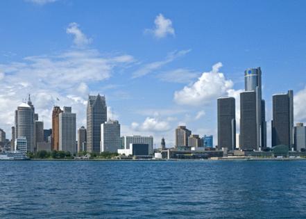
Detroit: Now
While Motor City's financial district may appear relatively unchanged from its 1920s art deco opulence, a 14-plus-acre development of connected skyscrapers known as the Renaissance Center (RenCen) transformed the city's skyline in the 1970s. The city planners behind the ambitious complex hoped the new buildings would revitalize the decaying downtown, reeling from the effects of deindustrialization and civil unrest. In 1996, General Motors purchased the complex for its headquarters, and renovations in 2004 and 2018 made the complex more accessible to the public.
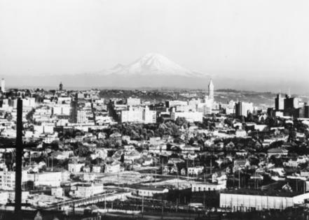
Seattle: Then
In this photo taken in 1921, Mt. Rainier is a dramatic backdrop to what was—and remains—the most populous city in the Pacific Northwest: Seattle. The tall building to the mountain's right is the Smith Tower, the city's tallest skyscraper (and the tallest building on the West Coast) for nearly 50 years after its construction in 1914.
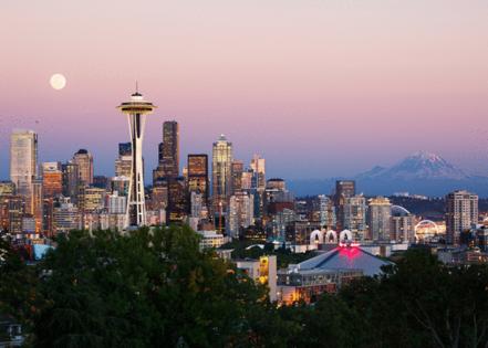
Seattle: Now
The Space Needle took the honor of being Seattle's tallest skyscraper in 1962 and now defines the cityscape. Seattle has endured its fair share of economic booms and busts—first in logging and mining, then in shipbuilding and airplanes—before settling into its current status as a tech center thanks to the presence of Microsoft and Amazon headquarters. Each stage of the city's history can be seen in its skyline, and as it continues to grow, Seattle still has many new developments and towers in the works.
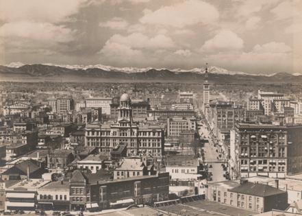
Denver: Then
This 1912 photograph of Denver prominently depicts the Daniels & Fisher Tower, the tallest building pictured. This 21-story clock tower was once connected to a five-story building, but in the 1970s, the smaller building fell victim to the city's Skyline Urban Renewal project and was destroyed. Saved from the wrecking ball, the Daniels & Fisher Tower remains today, its 20th-floor observation deck a fitting place to survey how much the city has grown around it.
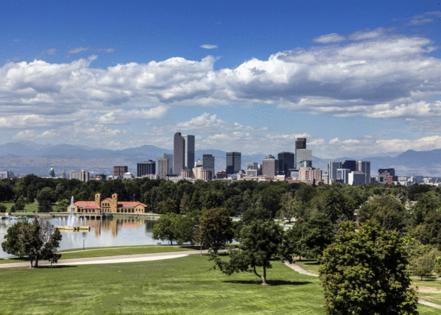
Denver: Now
Since the 1950s, special municipal codes have been in place to protect views of the Rocky Mountains by limiting the height of new construction in particular areas. As a result, the Rockies continue to dominate Denver's skyline. However, Mile High City has still grown over the past century, largely due to a building boom in the 1970s and '80s that resulted in some of the city's tallest buildings.
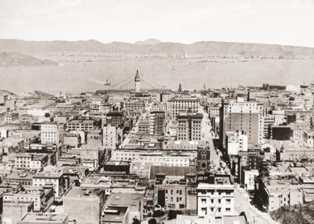
San Francisco: Then
In this birds-eye view of 1915 San Francisco, the Ferry Building on the waterfront towers above many downtown buildings. An icon of the city and, for years, its main entry point—the Ferry Building was once the second busiest transit terminal in the world—this Beaux Arts beauty survived two earthquakes to serve as a major tourist attraction and food hall today.
San Francisco: Now
Though the Ferry Building is still there, it certainly can't be seen in this photo from 2011, which shows the impressive vertical growth of the city's downtown. Built in 1972, the once-controversial Transamerica Pyramid defines the skyline in this image (the city's current tallest building, the Salesforce Tower, isn't pictured here). San Francisco's wealthy tech industry is driving the development of new and bigger buildings, primarily concentrated in the South of Market district.
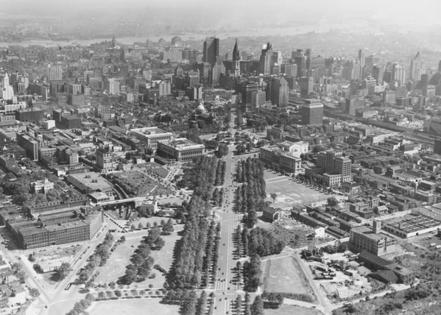
Philadelphia: Then
In this aerial photograph from 1930, Philadelphia sprawls over many high-rise buildings, civic structures, parks, and plenty of surrounding residences. After all, the city's population numbered nearly 2 million at the time.
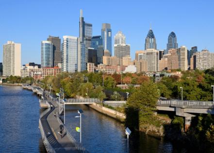
Philadelphia: Now
Aside from a handful of shiny and impressive skyscrapers, Philly's development over the last century hasn't been quite as dramatic as other cities. Perhaps that's because Philadelphia is a much older city than many others on this list and thus developed earlier—it's said that its skyline started taking shape in 1753. Another possible explanation is an understanding among developers that no building should exceed the height of the William Penn statue atop City Hall. However, this agreement was left by the wayside when the 61-story One Liberty Place was constructed in 1987.
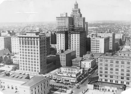
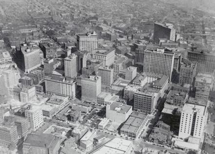
Houston: Then
A century after its founding as a port, Houston in 1929 exhibited the wealth from the early 1900s discovery of oil in the area. The two tallest buildings pictured here are the Esperson Building and the Texas Company Building (aka the Texaco Building), and the building under construction is the Texas State Hotel, which would become one of the finest hotels downtown. By 1930, Houston would become Texas' most populous city, filled by job-seekers hoping to make their fortune in the oil industry.
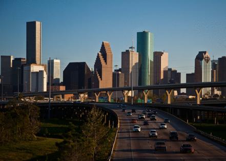
Houston: Now
In the 1940s, Houston tripled in size and developed a new city plan that included a series of highways around the city, as well as a 42-mile freeway called Loop 610. Construction on Loop 610 started in the 1950s and ended in 1973, changing the city's landscape. In the following decade, an embargo on overseas oil fueled another economic boom for the city's oil industry, resulting in rapid growth and significant new construction.
Atlanta: Then
Atlanta began as a railroad terminus, so transportation is a major part of the city's DNA. The city underwent a huge period of growth during the first decades of the 20th century, leading to the construction of many high-rise buildings seen in this 1926 photograph. The year before, the city launched an economic campaign called "Forward Atlanta" to eventually attract 750 companies.
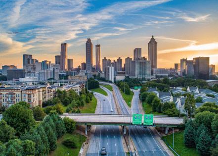
Atlanta: Now
Like other cities that boomed in the postwar era, Atlanta's vast metro region includes sprawling suburbs connected to the downtown core via an intricate freeway system. Today, Silicon Peach has been shaped by its history of racial segregation and the Civil Rights Movement, which was centered here. Atlanta underwent periods of significant development at various times of economic prosperity, such as the skyscrapers built in the Peachtree Center district in the latter half of the 20th century.
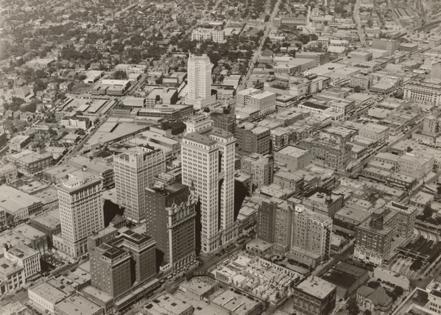
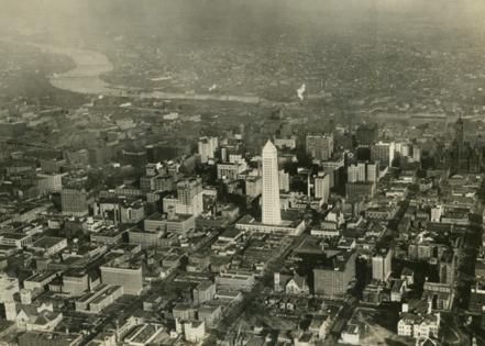
Dallas: Then
An aerial view of Dallas in 1925 features several high-rise structures, including the Magnolia Petroleum Company, the tallest building in the foreground and a signifier of the burgeoning oil industry's importance. Beside it on Commerce Street is the posh, 22-story Adolphus. Built by Anheuser-Busch cofounder Adolphus Busch in 1912, the hotel was the tallest building in Dallas for a decade.
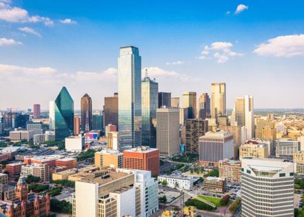
Dallas: Now
Though originally founded as a trading post, since the early 20th century, Dallas has been a hub for the oil industry, which has proven integral to the city's development. Downtown Dallas had a major building boom during the 1970s and '80s when rising oil prices inspired many companies to build bigger. Ten of the city's tallest skyscrapers cropped up in the 1980s alone.
Minneapolis: Then
Mills, lumber, and mines fueled the growth of Minneapolis in the 19th and early 20th century. In this photo from 1929, the newly opened 32-story Foshay Tower steals focus from the rest of the downtown area. Built by businessman Wilbur Foshay to resemble the Washington Monument, it was the Midwest's tallest building for 48 years.
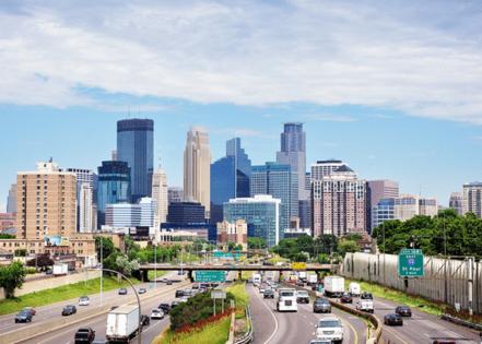
Minneapolis: Now
In this 2016 photo of downtown, Foshay Tower—now home to the W Minneapolis hotel—is surpassed in height and girth by many of the surrounding buildings. Most notably, the black-glass-and-steel IDS Center, located just behind and to the left of Foshay Tower, opened in 1972. Designed by architects Philip Johnson, John Burgee, and Ed Baker, the skyscraper is perhaps best known for its role in pop culture, as it featured prominently in the opening credits of "The Mary Tyler Moore Show."
Story editing by Cu Fleshman. Copy editing by Robert Wickwire.


Comments