Hurricane center tracking system off US East Coast
Published in News & Features
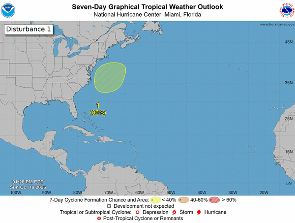
The National Hurricane Center continued Sunday to forecast a system could develop off the U.S. East Coast that has the potential to develop into a more dangerous storm.
As of the NHC’s 8 a.m. tropical outlook, a nontropical area of low pressure was expected to form by Sunday night off the coast of the southeastern United States.
“This low is likely to move slowly and erratically through the middle of this week, and some subtropical development is possible during that time,” forecasters said. “Regardless of development, this system will cause high winds, coastal flooding and dangerous surf along portions of the U.S. East Coast.”
The NHC gives it a 30% chance to develop in the next seven days.
The forecast area of development and any potential formation into a named system is farther north from Florida near the Carolinas and Virginia.
So far the 2026 hurricane season has produced nine named storms: Arthur, Bertha, Cristobal, Dolly, Edouard, Fay, Gonzalo, Hanna and Isaias.
The next name on the list is Josephine.
Only Isaias has reached hurricane strength during what has been a very slow Atlantic season amid effects from a strong global El Niño weather pattern. Isaias made landfall on Oct. 9 near Destin on Florida’s Panhandle as a Category 2 hurricane.
Hurricane season began June 1 and runs through Nov. 30, but the height of hurricane season runs from mid-August through mid-October.
The National Oceanic and Atmospheric Administration in August had updated its seasonal forecast to expect between seven and 13 named storms this year. Of those, two to six would become hurricanes.
An average year would see 14 named storms and seven hurricanes, with three of those growing to Category 3 strength or higher.
______
©2026 Orlando Sentinel. Visit orlandosentinel.com. Distributed by Tribune Content Agency, LLC.






Comments