Hurricane center tracking system drenching South Florida. Chance of strengthening low
Published in News & Features
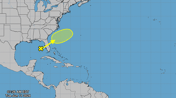
MIAMI — The National Hurricane Center is tracking a disturbance in the Gulf of Mexico that could blossom into a tropical depression as it crosses Florida, but not before dropping nearly a foot of rain in some spots.
While forecasters give the “large area of disorganized showers and thunderstorms” a pretty low chance of strengthening by week’s end when it emerges on the east side of the state — only a 20% chance — they noted it will bring a ton of rain to the southern portion of Florida this week.
All of South Florida is under a flood watch through Wednesday night.
The National Weather Service’s Miami office said the Miami area could expect 4 to 8 inches of rain through Thursday night, with the Naples area seeing evening more at 6 to 10 inches. The highest totals are expected near Everglades City at up to 12 inches of rain.
The weather service warned that higher totals, near 15 inches, cannot be ruled out along the Gulf Coast.
As of Monday morning, it appeared Wednesday could be the rainiest day.
In response to the rain worries, the South Florida Water Management District warned of a strong potential for flooding in low-lying and poorly draining spots, particularly along the coast.
“Over the next five days, rainfall is expected to be significantly above average for this time of year,” the district warned.
The district is working to lower its canals, test its gates and pumps and clear storm drains as the weather system moves across the state.
©2024 Miami Herald. Visit at miamiherald.com. Distributed by Tribune Content Agency, LLC.


Comments