Hurricane center watching blip in Atlantic. No threat but hints at busy season ahead
Published in News & Features
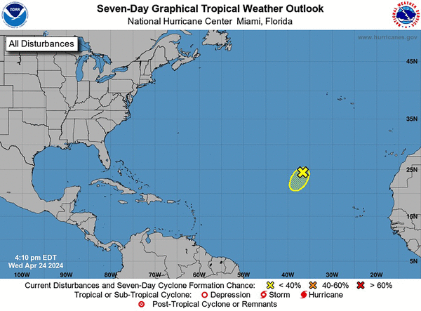
MIAMI — The National Hurricane Center is already watching something in the Atlantic, and it’s only April.
The low-pressure area in question is a thousand miles away from inhabited land and expected to dissolve in the next few days, but it’s also a reminder that the upcoming hurricane season is poised to be an active one.
The season officially starts June 1 and runs through November, although the hurricane center will start issuing regular daily outlooks in mid-May. Research suggests that the season could be seeing an earlier start due to climate change, which is helping warm the Atlantic Ocean and making it a friendlier place for storms to form earlier than normal.
And the Atlantic is hot this year. Really hot.
Sea surface temperatures near the disturbance are 24 degrees Celsius (about 75 Fahrenheit) when they’re usually around 21 degrees Celsius (70 Fahrenheit) this time of year, meteorologist Alex Boreham noted on Twitter.
The ocean heat content in the main development region of the Atlantic, the rectangular area where most storms develop and roll west toward the Caribbean and U.S., is currently at the average level for late June, according to records from Brian McNoldy, a senior research associate at the University of Miami.
While the gold standard for hurricane season predictions from NOAA isn’t due until next month, early predictions from Colorado State University and others warn that the steamy Atlantic is likely to lead to an above-average season. CSU predicted that the Atlantic could see 23 named storms this year, completely using up the main list of storm names NHC uses.
A new prediction from Pennsylvania State University released Wednesday calls for even more storms — 33 this season alone. That would top the record of 30 named storms from 2020, when the hurricane center was forced to turn to the Greek alphabet to name the last few storms.
Both predictions account for higher-than-usual Atlantic temperatures and the likely formation later this year of a La Niña, an atmospheric phenomenon that is linked with more storms forming in the Atlantic basin.
As for the first blip of the season, forecasters give it a slim chance — 10% — of surviving the next few days.
“Development is NOT EXPECTED, but this serves as a reminder that season (and a potentially early season is fast approaching),” tweeted Megan Borowski, lead meteorologist for Florida Storms.
The first name on the hurricane list this year is Alberto.
_____
©2024 Miami Herald. Visit miamiherald.com. Distributed by Tribune Content Agency, LLC.


Comments