Hurricane center gives low chance system could form in Gulf
Published in Weather News
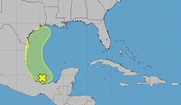
ORLANDO, Fla. — The National Hurricane Center said Friday an area of low pressure had formed off the coast of Mexico with a chance to develop when it moves into the Gulf next week.
As of the NHC’s 8 a.m. tropical outlook, the broad area of low pressure had formed over the far southern Bay of Campeche with disorganized showers and thunderstorms.
“Environmental conditions are forecast to be only marginally conducive for development before the system moves inland over eastern Mexico late Saturday or Sunday,” forecasters said. “The system could re-emerge over the northwestern Gulf on Tuesday and Wednesday while interacting with a frontal boundary, but there too, conditions are only expected to be marginally conducive for any development.”
The NHC gives it a 10% chance to develop in the next two to seven days.
The next update is at 2 p.m. with the NHC making updates every six hours at 2 a.m., 8 a.m., 2 p.m. and 8 p.m. for its tropical outlook report.
This is the first potential tropical system being tracked by the NHC in the Atlantic basin since the start of hurricane season.
The eastern Pacific has already been busy with three tropical storms, but so far the Atlantic basin has been quiet.
Hurricane season officially began June 1 and runs through Nov. 30. The height of hurricane season runs from mid-August into October.
The National Oceanic and Atmospheric Administration expects this season to be below normal with the official forecast released in late May calling for 8-14 named storms, of which 3-6 would become hurricanes. Of those, 1-3 would become major hurricanes reaching Category 3 status or above.
An average season has 14 named storms, seven hurricanes and three major hurricanes.
-----------
©2026 Orlando Sentinel. Visit at orlandosentinel.com. Distributed by Tribune Content Agency, LLC.


Comments