Current News
/ArcaMax
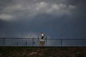
'Human error' led to errant tornado siren during Denver thunderstorms, city says
DENVER — The errant tornado siren that sounded across Denver during thunderstorms Monday afternoon was caused by “human error,” a spokesperson for the city’s Office of Emergency Management said.
There was no technology failure or malfunction, Loa Esquilín García said in a statement Tuesday. Rather, one or more employees did not ...Read more

Santa Monica Mountains' last steelhead trout survived the Palisades fire -- and even had babies
LOS ANGELES — Scientists feared the Santa Monica Mountains’ last remaining steelhead trout were dead, smothered by debris flows unleashed by the Palisades fire.
But the endangered fish surprised them: A team of biologists recently spotted 30 of the rare trout — and 21 babies — in Topanga Creek.
“There was a lot of happy dancing in ...Read more

Sean 'Diddy' Combs accused of sexually abusing child star in new lawsuit
NEW YORK — Sean “Diddy” Combs is facing yet another lawsuit, this one filed by a former child star who claimed he was abused by the disgraced music mogul when he was just a minor.
The defendant, identified only as John Doe, said he first met Diddy at a Hollywood Hills party — described to him as a networking event — back in 2007, ...Read more

NASA unveils 4 astronauts to fly on Artemis III mission
They won’t be flying to the moon, but will be paving the way. NASA announced today the four astronauts assigned to Artemis III, a mission targeting launch from Kennedy Space Center next year.
“So you want to find out who the astronauts are?” Isaacman said jokingly before revealing the quartet during an event at Johnson Space Center in ...Read more

'Broadview Six' grand jury transcripts to be released showing alleged misconduct by prosecutors
CHICAGO — Grand jury transcripts are expected to be released Tuesday detailing alleged misconduct by federal prosecutors in the “Broadview Six” case against Operation Midway Blitz protesters, which collapsed in dramatic fashion in court last month.
U.S. District Judge April Perry said in a court hearing Tuesday morning she will issue an ...Read more
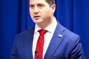
Essayli says he expects US attorney's office to file election fraud charges in California within a couple of months
WASHINGTON — First Assistant U.S. Attorney Bill Essayli said Tuesday that he expects his office to file election fraud charges within a couple of months as it continues to investigate allegations that California Democrats cheated in the state’s primary election.
“We are looking for any sort of wide-scale conspiracy, if you will,” ...Read more

Bill would make NYPD report all shots fired -- even when no one is struck
NEW YORK — The NYPD will have to make public any information about incidents in which someone fires a gun, even if no one is struck, under terms of a bill being considered by the City Council.
The Police Department currently posts on its website information about shooting incidents, defined as instances in which someone is injured or killed, ...Read more

Trump blames Iran for hitting helicopter, says US must respond
WASHINGTON — President Donald Trump said the United States must respond after he blamed Iran for shooting down an American military helicopter off Oman, posing a new threat to the peace deal he’s said for weeks is close.
“I have just been informed by our Great Military that last night the Iranians shot down one of our highly sophisticated...Read more
Maryland church fined $1,000 a day by city over homeless shelter
BALTIMORE — An Ocean City church is now facing daily $1,000 fines for operating an indoor homeless shelter that town officials say violates local zoning regulations, escalating a months-long dispute over how the resort should address homelessness.
Church officials said the first daily citation was delivered by Ocean City’s planning director...Read more

Kentucky State expects 20% drop in undergrads due to program cuts, strict enrollment rules
LEXINGTON, Ky. — The number of undergraduate students at Kentucky’s only historically Black university is expected to shrink by 20% by spring 2027, officials said Monday.
Students will be required to meet tougher academic and financial requirements, and some academic programs will be cut by the Fall semester due to a law passed by ...Read more

NASA to unveil 4 astronauts to fly on Artemis III mission
They won’t be flying to the moon, but will be paving the way. NASA is set to announce today the four astronauts assigned to Artemis III, a mission targeting launch from Kennedy Space Center next year.
The agency will reveal the crew during an event slated for 11:30 a.m. from Johnson Space Center in Houston, which will stream on NASA’s ...Read more
How Epstein tried exploiting Haiti aid efforts for ulterior motives
For Jeffrey Epstein, the relief efforts following the 2010 earthquake in Haiti that claimed hundreds of thousands of lives and devastated the Caribbean nation’s economy were just another opportunity to promote himself.
The earthquake struck about six months after Epstein had finished his jail sentence in Palm Beach County on solicitation ...Read more

Boston Mayor Michelle Wu's financial chief warns City Council off further budget changes that would lead to layoffs
BOSTON — Boston Mayor Michelle Wu’s financial chief urged the City Council to stick to an $8-9 million budget amendment package proposed by the Council’s Ways and Means chair, warning that further changes would lead to city layoffs.
Chief Financial Officer Ashley Groffenberger said amendments proposed by councilors other than Ways and ...Read more
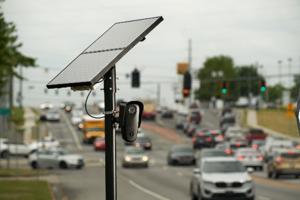
Push to install license plate readers comes amid questions about how data are shared
LOS ANGELES — Since its creation more than a century ago, the Los Angeles Bureau of Street Lighting has been in the lamppost business and little else.
But in recent months, the little-known city agency has found itself pulled into a fierce debate over L.A.'s relationship with Flock Safety, a surveillance technology company that has been ...Read more

Miami police investigating online threats against city commissioner
MIAMI — The Miami Police Department is investigating threats against City Commissioner Miguel Angel Gabela that appeared in the comment section of a recent video posted to Instagram by filmmaker Billy Corben.
The investigation lands amid ongoing tensions between Gabela and Corben, who has posted several videos to Instagram in recent weeks ...Read more

New York Gov. Kathy Hochul extends bar hours for FIFA World Cup
NEW YORK — When the games are on, the bars will be open.
With the FIFA World Cup just around the corner, Gov. Kathy Hochul on Monday signed a bill allowing bars across New York to stay open until 4 a.m. for the duration of the tournament. The competition runs from June 11 through July 20 and will feature more than 100 matches across the ...Read more
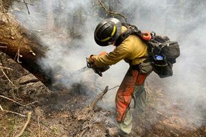
Firefighters face a higher risk of skin cancer – nano fabrics with tiny, rough fibers can help keep them safer
Wildland firefighters are exposed to a mix of harmful chemicals in the smoke they breathe and the ash and soot that gets on their clothing. Over long assignments fighting fires that can last for days to weeks, those chemicals can be absorbed by their skin.
Some of those chemicals are carcinogens. A 2025 study found that firefighters ...Read more

Summer between high school graduation and college is a critical time for preventing risky behaviors – here’s how parents can play a key role
Early summer is a valuable time for parents and young people to prepare for the transition to college in the fall.
As first-year college students arrive on campus every fall, a predictable pattern unfolds. Rates of heavy drinking spike, social pressures intensify, and the risk of sexual assault, injury and other harms increases.
...Read more
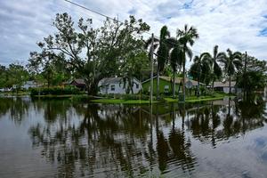
Home insurance and the unraveling of Florida communities
While visiting family in St. Petersburg, Florida, in November 2024, I found myself walking down a quiet residential street in Shore Acres, a low-lying, bayfront neighborhood not far from where I grew up.
Two months earlier, Hurricane Helene had sent several feet of water into homes here, even though the center of the storm had stayed ...Read more

Who is allowed to walk on the beach? It depends on where you live
Summer is here – the perfect time to take a walk on a beach. But doing so is not always as simple as it might sound.
In Wisconsin, for instance, a legal case has stretched for months over whether Paul Florsheim may keep walking on a Lake Michigan beach he has walked for over 50 years.
In July 2025, Florsheim, a retired ...Read more
Popular Stories
- Who is allowed to walk on the beach? It depends on where you live
- Home insurance and the unraveling of Florida communities
- Summer between high school graduation and college is a critical time for preventing risky behaviors – here’s how parents can play a key role
- Xi pledges deeper ties with Kim while avoiding nuclear issue
- Firefighters face a higher risk of skin cancer – nano fabrics with tiny, rough fibers can help keep them safer
Comics